Menard to Fort McKavett
Menard
South of Paint Rock, US-83 winds through another 40 mi (64 km) or so of scrubby hills before reaching the fascinating old wool-products market town of Menard (pop. 2,139; pronounced “muh-NARD”), standing in a lush valley along the San Saba River. A trading post and stop on the old cattle trails, Menard was originally founded by Franciscan missionaries in 1757, and many of its early structures survive or have been restored.
It’s a picturesque little place, with huge trees, solid old brick storefronts, and a wide bridge over the river. The Menardville Museum, is housed in the old Santa Fe Railroad Depot, and the Legal Tender Saloon is worth a stop. A block south of the old main drag, the Historic Ditch Walk follows a section of the 10-mile (16-km) Vaughn Agricultural and Mechanical Canal, a fancy name for an irrigation ditch that has served local farmers since 1876. The canal features an old waterwheel, and the walk passes the 1899 Sacred Heart Catholic Church and a vintage Sinclair filling station before finishing up, appropriately enough, at Menard’s summer-only outdoor swimming pool.
Several historic limestone buildings in town date to the turn of the 20th century. The Luckenbach Building (built in 1903) contains the Burnham Brothers Co. (325/396-4572), the oldest U.S. retailer of game calls, from simple wooden instruments to state-of-the-art computerized devices that lure turkey, deer, elk, ducks, and other animals.
During Menard’s annual Jim Bowie Days in late June, visitors and residents gather for arts and crafts shows, live music, and rodeos.
On the main highway there are a couple of moderate motels, like the Motel 83 (325/396-4549, $45), which is attached to a popular bar, Shifty’s.
San Sabá Mission
Off US-190, 1 mi (1.6 km) west of Menard, a cemetery and foundations of a few buildings are all that’s left of Mission Santa Cruz de San Sabá. Established in 1757 as Spain’s northernmost outpost in the Apache and Comanche lands of what is now Texas, the mission was abandoned in 1768 after repeated Comanche attacks. Now in a county park next to a golf course along Hwy-29, the rebuilt chapel houses a small museum; portions of a later stone fort, named Real Presidio de San Sabá, also survive. A simple inscription, “Bouie,” on the stone gate is thought to have been carved by Jim Bowie of Alamo fame (“Bouie” was the proper historical inscription of his name). Bowie lived at the presidio ruins while searching for buried Spanish silver during the early 1800s.
Fort McKavett State Historic Site
Farther along US-190, 17 mi (27 km) west of Menard then another 6 mi (9.6 km) south on Hwy-864, Fort McKavett (325/396-2358, daily, $4 adults) was estanlished in 1852 as the “Camp on the San Saba.” It served as a first line of defense against Comanche raids along the Texas frontier and provided protection for travelers along the Upper San Antonio-El Paso Trail. Temporarily abandoned in 1859, the post was reestablished in 1868 after local residents lobbied for Army protection. All four of the Army’s African-American units, whose ranks came to be known as “Buffalo Soldiers” by the indigenous people, eventually served at McKavett, including the famous 9th and 10th Cavalries. Twenty-one of the original 40 buildings have been restored, including the officers’ quarters, barracks, hospital, school, bakery, and post headquarters. The hospital ward serves as a visitors center and contains interpretive exhibits explaining the natural and military history of the area. A nature trail, passing through pastures of spring wildflowers, leads to a shady dell around the clear waters of Government Springs.
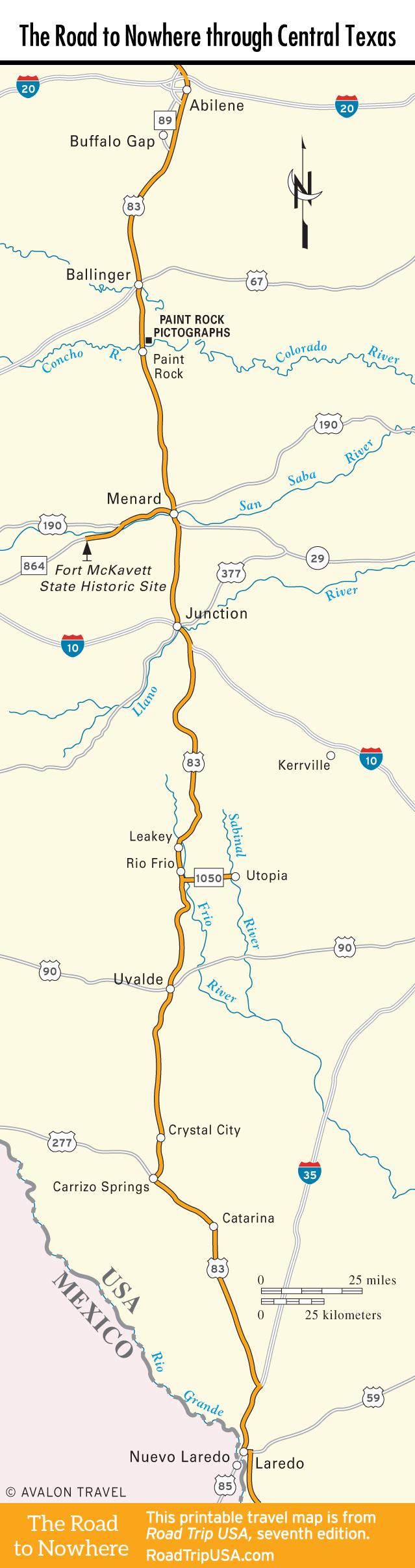
Travel Map of the Road to Nowhere through Central Texas
Related Travel Guides for the Road to Nowhere