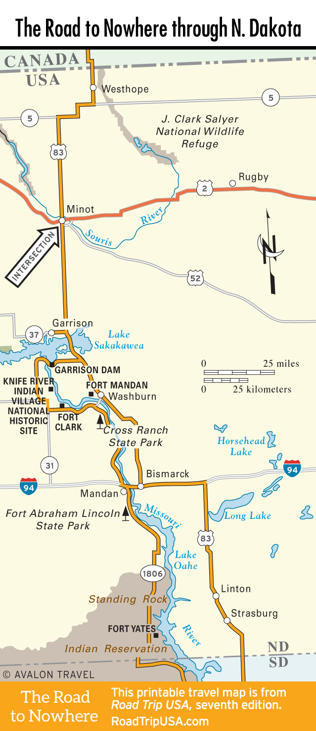
Washburn and Cross Ranch State Park
Washburn
Now a tranquil little highway town, Washburn (pop. 1,283) was once a frenetic Missouri River ferry crossing, served by steamboats from St. Louis, the last of which has been mounted on a concrete pedestal at the base of the bridge that helped to make it obsolete. In addition to nearby Fort Clark, across the river, and Fort Mandan, two mi (3.2 km) to the northwest, Washburn has the excel lent Lewis & Clark Interpretive Center (701/462-8535, daily Apr.- Sept., Mon.-Sat. Oct.-Mar., $8). It’s at the intersection of US-83 and North Dakota Hwy-200A, an ideal jumping-off point for your exploration of the lower Missouri River valley. Offering the hard-to-find combination of informative exhibits (including a full set of the detailed watercolors painted in the 1830s by explorer-artist Karl Bodmer), great Missouri River views, an excellent gift shop, and impeccably clean restrooms, this is a place you will want to linger for at least an hour or maybe two. The highly interactive museum exhibits let visitors enjoy Native American sports, sample historic foods, and try heirloom seed gardening.
Cross Ranch State Park
Across the Missouri River, a little more than 8 mi (12.9 km) south of Washburn via Hwy-1806, Cross Ranch State Park ($5 per car) is set among 589 ac (238 ha) of cottonwood-shaded free-flowing Missouri River bottomland with numerous hiking trails, canoe rentals, and fine camping, with sites for RVs and tents. There are also furnished log cabins and yurts (cabins $80 and up, yurts $65 and up). For details, phone the park visitors center (701/794-3731 or 800/807 4723), which also has canoe and kayak rentals and information on the annual Missouri River Bluegrass Festival, held here in the middle of June.
Across Hwy-1806 from the state park, the remains of the pioneer town of Sanger stand as a mute memorial to Great Plains history. Founded in 1879, Sanger was the county seat and a major steamboat and railroad town, with a population of about 400 people. By World War II, Sanger had effectively been bypassed by the modern age, and the post office closed down in the mid- 1950s. By 1985, just three residents remained.
From the state park, enticing trails lead into The Nature Conservancy’s 5,593-acre Cross Ranch Preserve (701/794-8741, daily dawn-dusk, free). One of the richest surviving native Missouri River valley ecosystems, the preserve includes floodplain prairie and riparian forest, plus a resident herd of bison and some undisturbed Native American archaeological sites.
Travel Map of the Road to Nowhere through North Dakota
Related Travel Guides for the Road to Nowhere