Texas Hill Country to Crystal City
Texas Hill Country: Lost Maples and Utopia
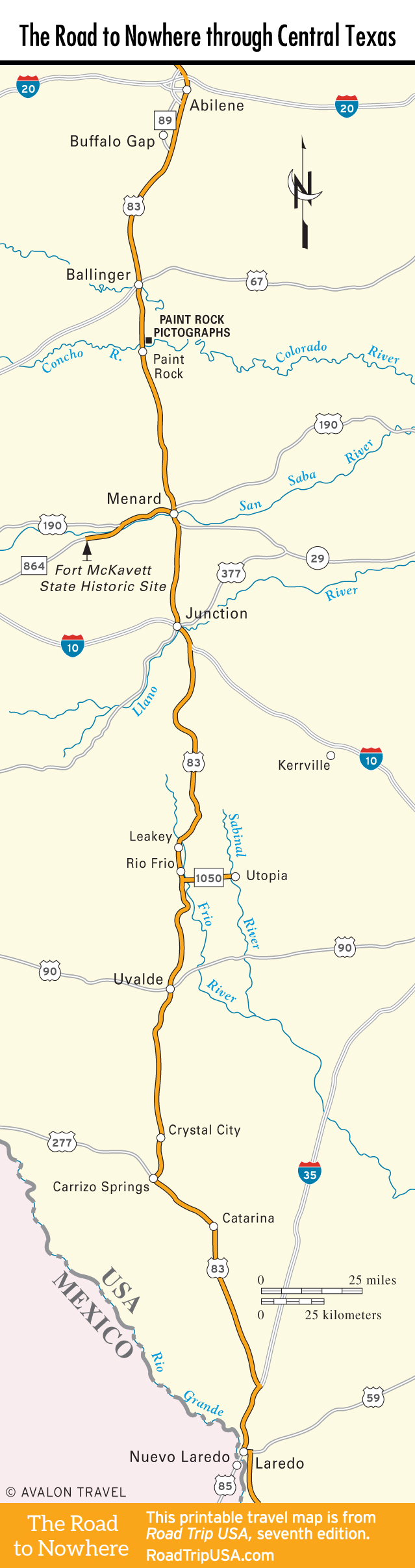
While the landscape along US-83 is pleasant, the scenery is much more rugged and beautiful if you detour to the east, into the heart of the Texas Hill Country. East of Leakey via Hwy-337 and then Hwy-187, there’s a wonderful drive to Lost Maples State Natural Area, where miles of hiking trails take you away from the road into deep canyons carved by the Sabinal River. The “lost maples” of the name refers to a grove of big-leaf maples, which in October provide a taste of New England’s famous fall color. The rest of the year, Lost Maples is a real oasis: Texas laurels and wildflowers offer spring blooms, while juniper scent and birdsong fill the air. For the best overview, take the East Trail, a 4.4-mile (7-km) loop that starts at the maple grove and climbs swiftly over a plateau before dropping down to a pond at the foot of limestone cliffs. The pond is home to snakes and black leeches, so it’s not for swimming. Camping (800/792-1112, starting at $10) is available, and a couple of nearby ranches offer characterful accommodations, like the Foxfire Cabins (830/966-2200, $130 and up, with off-season deals).
South of Lost Maples, 15 mi (24 km) east of Rio Frio via Hwy-1050, the Sabinal River town of Utopia represents a legacy left by frontier circuit preachers who found this spot a heavenly place to hold camp meetings and save souls. “A Paradise—Let’s Keep it Nice,” a sign says. The Sabinal Canyon Museum (830/966-2100, 10am-4pm Sat., 1pm-4pm Sun.) on Main Street displays local arts and crafts, including antique handmade quilts, historic photos, farm implements, arrowheads, spurs, and other artifacts that outline Bandera County history. Across from the museum, Utopia’s best place to eat is the Lost Maples Café (830/966-2221).
Uvalde
South of Leakey about 40 mi (64 km), US-83 crosses US-90 (the former San Antonio-El Paso Trail) at Uvalde (pop. 16,181), founded in 1855 and still centered on a broad square that originally served as a wagon yard for teamsters and travelers. Uvalde was the home of a Western legend, the late, great celluloid cowgirl Dale Evans. The town’s most famous native son, John Nance “Cactus Jack” Garner, served as Franklin Delano Roosevelt’s first- and second-term vice president from 1933 to 1941. After retiring from politics, Garner returned to Uvalde and lived here until his death in 1967 at age 98. His home is now owned by the University of Texas and contains the Briscoe-Garner Museum (333 N. Park St., 830/278-5018, Tues.-Sat.), a repository of memorabilia from Garner’s fascinating political career.
Crystal City
As US-83 continues south from Uvalde, the highway descends farther onto the mostly flat Rio Grande Plain, entering a subtropical zone of seemingly endless chaparral. Amid this scrubby “brush country”—marked by a mixture of thorny cacti, mesquite, dwarf oak, black bush, and huisache—spread large irrigated farms known as the “Winter Garden of Texas” for the bounty of spinach and citrus crops they produce. Nearly 40 mi (64.4 km) south of Uvalde sits Crystal City (pop. 7,138), the Zavala County seat and self-proclaimed “Spinach Capital of the World,” home to a statue of the world’s most famous spinach lover, Popeye, in front of the city hall.
Travel Map of the Road to Nowhere through Central Texas
![[object Object]](https://content.roadtripusa.com/wp-content/uploads/2021/06/9781640499812.webp)