Junction and Leakey
Junction
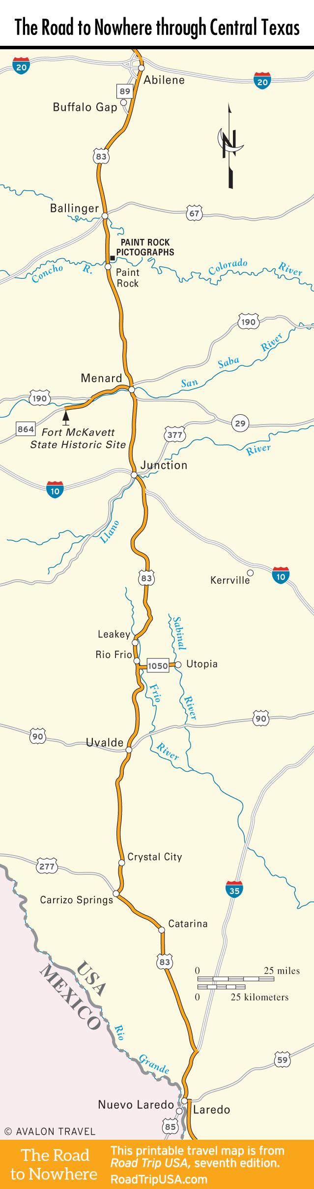
After passing through the attractively rugged but shallow canyon lands south of Menard, US-83 crosses high-speed I-10 at the aptly named town of Junction (pop. 2,418). Once a major crossing where the east-west Chihuahua Trail met a branch of the north-south Chisholm Trail (now I-10 and US-83 respectively), Junction sits at the edge of Texas’s famed Hill Country, where the Edwards Plateau crumbles into limestone canyons and cliffs along the Balcones Escarpment. As in the areas to the immediate north, wool and mohair production are the main means of local livelihood, supplemented by pecan farming (not to mention catering to passing travelers).
From Junction, I-10 heads southeast to San Antonio, passing through the Hill Country town of Kerrville, which hosts the popular Kerrville Folk Festival (830/257-3600) around Memorial Day.
To continue south along US-83, you can wind along Main Street or follow I-10 southeast for one exit, roughly 2 mi (3.2 km), to rejoin the old road. Another nice drive is along US-377, which traces a scenic route along the Llano River southwest of Junction, bisecting typical Edwards Plateau tableaus of limestone arroyos studded with mesquite, oak, prickly pear, and yucca. South Llano River State Park (325/446-3994, $5 adults), 5 mi (8 km) southwest of Junction off US-377, protects 2,600 wooded acres (1,052 ha) and abundant wildlife (white-tailed deer, Rio Grande turkeys, bluebirds, finches, and javelinas) and offers facilities for picnicking, camping, hiking, mountain-biking, canoeing, tubing, and swimming.
Leakey and the Frio Canyon
South of Junction, US-83 continues southward through nearly 62 beautiful mi (100 km) of rolling ranches and native pecan orchards, entering a verdant spring-filled region that was one of the last strongholds of the Lipan Apache and Comanche people. The rolling hills around Leakey (pop. 446; pronounced “LAY-key”; “Home of the 1975 State Football Champions”) hold limestone caves, some of which the Confederates mined for bat guano to make saltpeter—an essential ingredient of gunpowder—during the Civil War. At 1,600 ft (487.6 m) above sea level, this is one of US-83’s prettiest stretches through Texas, as the road follows the clear, cold Frio River through 17 mi (27 km) of cypress, pecan, live oak, cedar, walnut, wild cherry, piñon, and mountain laurel. Some areas also have Bigtooth maples and sycamores, a major tourist attraction in the late fall when the leaves change color. You’ll find a dozen or more camps and lodges along this stretch of US-83, including the tin-roofed, wooden-sided Historic Leakey Inn (527 S. US-83, 830/232-5246, $79 and up), in the center of Leakey, and the peaceful River Haven Cabins (866/232-5400, $85 and up), 3 mi (4.8 km) southeast of town along Hwy-1120.
About 10 mi (16 km) south of Leakey along US-83, the pretty and popular Garner State Park (830/232-6132) offers campgrounds, cabins, hiking trails, kayak rentals, paddle boats, river swimming, and a popular summertime dance terrace on the banks of the Frio River.
Travel Map of the Road to Nowhere through Central Texas
Related Travel Guides for the Road to Nowhere