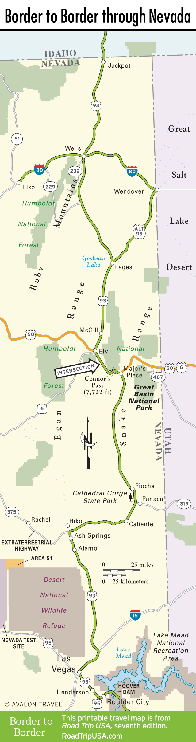
Jackpot to the East Humboldt Range
Jackpot
In every respect but one, Jackpot (pop. 1,200) belongs more to Idaho than Nevada—a somewhat incongruous introduction to US-93 in the Silver State. Jackpot’s visitors and workers mostly come from Idaho, as do its power and water; even its clocks are set to Idaho time. The one little exception, however, is pure Nevada: border-town gambling. Jackpot was founded in 1954, mere months after Idaho banned slot machines, which didn’t, to be sure, reduce the demand. In fact, Jackpot has thrived, as a pit stop in any of the town’s casinos will attest. Jackpot is compact enough to give long-distance travelers just enough lights, action, and comfort to satisfy more immediate needs and then send them on their way again.
Cactus Petes (775/755-2321, $89 and up) is the 10-story tower you can see for miles. Along with the big casino, it has a great snack bar, a buffet, a sit-down restaurant, and a showroom, and there’s more of the same in the Horseshu across the highway. Both casinos are owned and operated by the same firm, Ameristar, which got its start here in Jackpot in the 1950s.
Wells
Some lone peaks, a stretch of badlands and buttes, and a couple of north-south ranges usher US-93 down a long basin toward the little junction town of Wells (pop. 1,261). Just under 70 miles from Jackpot at the interchange of US-93 and the I-80 freeway, Wells was named by the Central Pacific Railroad, which chose the site for a depot and town to make use of the plentiful springs in the hills a few miles northeast. Before Wells got hammered by a devastating earthquake in 2008, the old downtown had the most intact abandoned railroad row on the entire main line across northern Nevada. Now many of these old landmarks languish. Wells provides an explicit illustration of the Wild West’s transition from open range to rail to road to superhighway. The newest action in town is around the east- and westbound exit ramps of I-80, while the 1950s-era “strip” stretches along the old Victory Highway around 6th Street.
East Humboldt Range
The I-80 town of Wells is situated at the northeastern base of the splendidly scenic East Humboldt Range. To get into these rugged, glacier-scraped mountains, head briefly west from Wells on I-80 to exit 351, from where Hwy-231 runs 12 miles south and west, climbing to about 8,400 feet before terminating at alluring Angel Lake. For details on the abundance of hiking, camping, and outdoor recreation hereabouts, contact the U.S. Forest Service ranger station (140 Pacific Ave., 775/752-3357) at the west end of Wells.
Continuing down US-93 affords a different view of the East Humboldts. Ten miles south of Wells, you can head west on Hwy-232, which makes a 14-mile loop through luxuriant Clover Valley at the eastern base of the mountains, one of the most bucolic basins in Nevada. About halfway along is a turn leading west up into Week’s Creek Canyon. Look up to see Hole-in-the-Mountain Peak (11,300 feet). The tallest peak in the East Humboldts, it features a 30-by-25-foot natural window in the thin rock 300 feet below its summit, which gives you a spectacular little patch of blue (or silver, orange, or purple, depending on the time of day) right through the top of the range.
Related Travel Guides

Travel Map of the Border to Border Route through Nevada