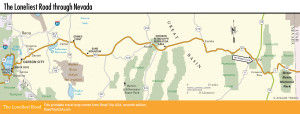
Nevada
Between Lake Tahoe in the west and Great Basin National Park on the Utah border, US-50 crosses more than 400 mi (645 km) of Nevada’s corrugated country, climbing up and over a dozen distinct mountain ranges while passing through four classic mining towns and the state capital, Carson City.
Early explorers mapped this region, Pony Express riders raced across it, and the long-distance Lincoln Highway finally tamed it, but the US-50 byway has always played second fiddle to the I-80 freeway, the more popular northern route across the state. Besides being a more scenic alternative to the mind-numbing, and therefore accident-prone, I-80, US-50 across Nevada has gained a measure of notoriety in its own right—it’s known as the “Loneliest Road in America.” As you travel along it you’ll see road signs, T-shirts, and bumper stickers proclaiming it as such.
Inspired by the July 1987 story in Life magazine that dubbed US-50 “The Loneliest Road,” the state-run Travel Nevada (800/NEVADA-8—800/638-2328) sponsors a tongue-in-cheek promotion in which trans-Nevada travelers can earn themselves a certificate saying “I Survived the Loneliest Road in America.” Get your official US-50 travel passport stamped at visitors centers along the highway.
Travel Maps of Nevada
Related Travel Guides