Woodville
Rolling and curving past hay fields and woods, the distinctively red earth of southern Mississippi crowding the soft shoulders, the GRR passes quickly over the 45 mi (72 km) between Natchez and the Louisiana state line. You won’t see it from the highway, but just across the Mississippi River is possibly the most significant piece of engineering anywhere along its length: the Old River Control Project. More than mere flood control, the project is designed to keep the Mississippi going down to Baton Rouge and New Orleans, rather than finding a new route to the Gulf via the Atchafalaya River. This actually happened during the 1948 flood, and there are hydrologists who predict it is only a matter of time before it will happen again—a potential economic catastrophe for downstream cities along both rivers.
About 10 mi (16 km) north of the Louisiana border, an unprepossessing intersection of gas stations marks the turnoff west for Woodville (pop. 938), where a lovely old courthouse sits at the center of a green square full of stately old oak trees, and three historic churches line the somnolent streets.
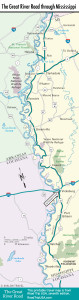
Map of the Great River Road through Mississippi
Related Travel Guides