Aitkin to Little Falls
Aitkin
South of Grand Rapids, the land rivals Kansas for flatness, yet the mix of farms and forest continues to lend visual interest to what could otherwise be achingly monotonous. The GRR alleviates boredom with its sinuous irregularity, the curves always hinting at the proximity of the Mississippi. For most of the way the river itself remains hidden, although regular signs for boat landings confirm its presence, and, on occasion, its broad channel and tree-lined banks roll into view.
For nearly 70 mi (113 km) south of Grand Rapids you will have this rural road to yourself; then at the single stoplight in Aitkin (pop. 2,001), the GRR joins busy Hwy-210, at the edge of the mid-state lakes region. Aitkin is best known as the site of the annual Fish House Parade, in which ice fishers show off their one-of-a-kind refuges from the winter cold; this unique event is held every year on the Friday following Thanksgiving.
Crosby
Watch your compass needle for signs of deflection as you proceed to the small but tidy town of Crosby, the center of Minnesota’s “forgotten” iron range, the Cuyuna. The flood-prone mines have died out, but the surrounding landscape still bears evidence of mining’s heyday, with lakes and hills created by subsidence and strip mining, and also by contemporary gravel quarrying. Crosby itself has a nice park fronting onto Serpent Lake, complete with a brightly colored 20-ft-high (6-m), 25-ft-long (7.6-m) sea serpent.
South of Crosby, the GRR leaves the truck traffic and takes to the cornfields and sumac-laced forests again, passing as many barns as houses, the occasional lakeside hideaway, and some rural town halls. For a thumbnail overview of the area’s settlement history, keep an eye peeled for the historical markers along the way.
Brainerd
At roughly the geographical center of the state, Brainerd (pop. 13,465) is a medium-size Minnesota town that played a starring role in that offbeat Coen brothers movie Fargo.
The economy of this part of the state benefits greatly from recreation. In Minnesota this means lakes: more than 400 within a 50-mi (80.5-km) radius, with over 150 resorts or campgrounds on their shores. Brainerd, the commercial center of it all, began life in 1870 when the Northern Pacific Railroad chose to cross the Mississippi River here. The rail yards are still in the heart of town beneath the giant water tower, which resembles a Las Vegas-style medieval castle. The historic downtown has been badly “malled” by outlying shopping plazas. But among the discount merchandisers, pawn shops, and empty storefronts, there are still a few points of light, such as The Barn (711 Washington St., 218/829-9297), serving all you could want, including breakfasts, burgers, Maid-Rite-style sloppy joes, fries, and fresh fruit pies.
East of downtown Brainerd, there is a 26-ft (7.9-m) statue of a sitting Paul Bunyan at Paul Bunyan Land (17553 Hwy-18, 218/764-2524, daily summer), part of the 23-ac (9.3-ha) kid-friendly rural-history theme park. The 4th of July in Brainerd is a big event, with marching bands, rock bands, and parades.
Many chain motels are clustered along the GRR (Hwy-371).
Crow Wing State Park
South of Brainerd, the GRR speeds along Hwy-371, which yearns to be an interstate for the 30-odd straight mi (48 km) it takes to reach Little Falls. Exceedingly flat and awash in a sea of corn, the region gives no hint of the Mississippi River except at Crow Wing State Park (218/825-3075, $5 per group). Indigenous people, missionaries, fur trappers, and lumberjacks made Crow Wing a thriving settlement until the 1870s, when the forced removal of the Native Americans and the shift of trade to the rail crossing at Brainerd turned Crow Wing into a ghost town. These days only a cemetery and a single surviving home remain around the old town’s site, while trails, a picnic area, and campsites spread out beside the confluence of the Mississippi and Crow Wing Rivers.
Little Falls
At Little Falls the GRR neatly misses the fast-food and gas claptrap that has sprung up along the busy Hwy-371 bypass, proceeding instead through the heart of town, which would probably still be recognizable to aviator Charles Lindbergh, who spent his boyhood summers here a century ago. Running along the west bank of the river, the GRR passes by the Charles A. Lindbergh Historic Site (1620 Lindbergh Dr. S., 320/616-5421, Thurs.-Sun. summer, $8). The house, which sits over a mile (1.6 km) south of town on a beautiful stretch of the Mississippi, bears the unusual distinction of having been restored with the meticulous guidance of “Lucky Lindy” himself. Lindbergh wanted the site to honor his father, a five-term U.S. congressman, as well as himself, and so it does.
Exhibits also illustrate the junior Lindbergh’s life and achievements after his historic solo flight across the Atlantic in 1927. There is little mention of Lindy’s public admiration for Adolf Hitler, but the museum does display Lindy’s 1959 VW Beetle, which he drove more than 170,000 miles on four continents.
South of Little Falls, agriculture continues to dominate the landscape, but as our route approaches the junction with I-94 at St. Cloud, the loss of farms foreshadows what is to come downriver. For nearly 100 mi (161 km), the GRR does its best to offer a scenic alternative, but sprouting subdivisions and suburban mini-malls make it hard to enjoy. I-94 parallels the GRR and the Mississippi River all the way through the heart of the Twin Cities, and for better or worse it’s pretty much the closest you’ll get to a riverside highway. If you were hoping to follow the river through this stretch (by car, at least), you’re out of luck.
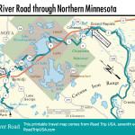
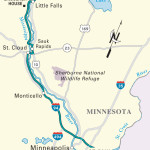
Travel Maps of the Great River Road through Minnesota
Related Travel Guides