By Leigh Bernacchi, author of Moon Sequoia & Kings Canyon
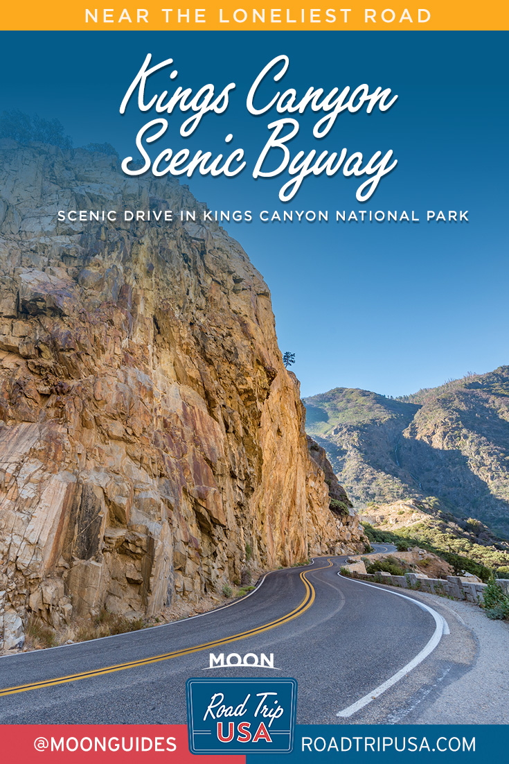
The 34-mile (55-km) drive along the Kings Canyon Scenic Byway, which is typically open to traffic from late April to November, allows you to explore one of North America’s deepest canyons from the comfort of your own vehicle. You’ll drive along a zigzagging road next to the roaring Kings River, among granite, wildlife, and wildflowers aplenty.
This drive starts at Grant Grove Village and traces Highway 180 north and east until Road’s End. Drive 10.5 miles (17 km) north on Highway 180 to Junction View, an overlook on the left side of the road. This is a spectacular angle from which to see the depth of Kings Canyon.
Continue downhill, observing high elevation plants such as blazing stars, which trace the highway with eruptions of their spiky blooms. Twisting and turning on the two-lane road, you’ll arrive at a bridge over Tenmile Creek, an outlet of nearby Hume Lake.
Continue down Highway 180. At 14 miles (23 km), you’ll reach Yucca Point Trail, a good fishing spot where you can hike into the canyon and see firsthand the confluence of the Middle and South Forks of the Kings River.
At 18 miles (29 km), you’ll start the drive into the canyon itself. The road heads east and meanders along cliffsides in a series of fun zigzags above the river. Across the canyon is a sheer slate-colored face. This is home to the Boyden Cavern. You’ll reach its parking lot at mile 19.5 (km 31). Stop for an hour and enjoy a guided tour through this unique geological underworld.
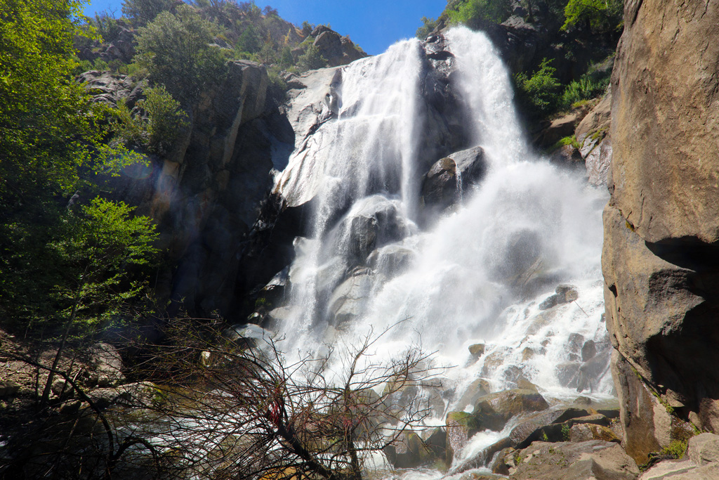
In another 5 miles (8 km), you will reach a small parking lot for Grizzly Falls, a lovely cascade that can be viewed from the car, a designated picnic area, or at its misty base, just a short walk from the parking lot.
Over the next 10 miles (16 km), you will experience the totality of Highway 180. Stop at Cedar Grove Village, taking the second left north and following the park service signs. Here you’ll find a restaurant and market, as well as the Cedar Grove Visitor Center.
As you approach the highway’s eastern terminus, you can get out of the car and explore Roaring River Falls and Zumwalt Meadow, both of which offer stunning views of the area.
The drive ends at the appropriately named Road’s End. Here you can stand on Muir Rock and peer into the King River’s crystalline waters, or go on one of several hikes.
Go slowly on this drive. Downshift into a lower gear (rather than ride your brakes) and use turnouts. Trailers longer than 24 feet (7 m) are not recommended on Highway 180.
Sights along California Highway 180
Boyden Cavern
This part of the park is hot from June to September, regularly reaching over 90°F (32°C). To cool off, go underground and explore Boyden Cavern (19 mi/31 km northeast of Grant Grove, Hwy. 180, 888/965-8243, tour times vary by season, $16 adults, $8 children 5-12, $5 children 4 and under). Technically located in Sequoia National Forest, this cave is set at the base of a canyon. On a tour of this cave, led by a geology expert, you can spend a couple of hours exploring what took 100,000 years to form. You’ll see how water has carved through marble to create strange formations that resemble tiny straws, shards of glass, a stack of pancakes, and a giant wedding cake. The tour covers about 750 feet (230 m) of cave in 50 minutes, and is suitable for all ages. If you are only visiting the northern half of the park, this is a wonderful alternative to Crystal Cave.
Book your tour spot online or in person. Advance reservations are not required. Budget approximately two hours for this attraction to give yourself enough time to get here, purchase tickets, and browse the souvenir shop afterward. Bring a jacket for inside the chilly cave.
To get to Boyden Cavern from Cedar Grove, it’s a 10-mile (16-km) drive west on Highway 180, which takes around 15 minutes. From Grant Grove, it’s a 20-mile (32-km) drive northeast on Highway 180, which takes less than an hour.
Just 0.5 mile (0.8 km) before Boyden Cavern is a turnout on the east side of the road. Park and walk upstream about 100 yards to feast your eyes on layers of zig-zagging rock. The folds were formed over eons as the tectonic plates underneath them shifted.
Grizzly Falls
Make a quick stop to cool down in the spray from the beautiful Grizzly Falls. Set in a shady canyon, these cascades bounce and flutter off of dark rocks, affording waterfall lovers a quick photo op.
There’s a picnic area by the road. It gets a little noisy and dirty here, but the waterfall sure is beautiful. There’s a bathroom here. Dogs are permitted.
From Cedar Grove, drive 4.5 miles (7 km) west and park at the signed turnout on the north side of Highway 180. Follow the short dirt and rock path for about 0.1 mile (160 m) to reach the falls.
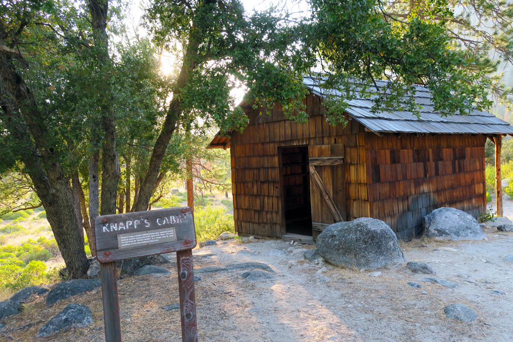
Knapp’s Cabin
In the 1920s, a wealthy industrialist and philanthropist, George Knapp, built this cabin to store gear for his fishing and hunting outings. Perched on a glacial moraine above the Kings River, Knapp’s Cabin is a humble, windowless, one-room shed, constructed of rot-resistant cedar. It’s less than 200 square feet in size. The sheltered porch overlooks the river. The cabin has sat empty since the establishment of Kings Canyon National Park in 1940. It was added to the National Register of Historic Places in 1978.
From the road, it’s just a 50-yard walk to reach the cabin. The best times to visit are in the morning or evening, when the light is optimal for admiring the surrounding views. To get here, look for the signed turnout on the north side of Highway 180, 2 miles (3 km) east of Cedar Grove.
Roaring River Falls
Refresh yourself in the snowmelt spray of Roaring River Falls. Here, a lush band of alders and cottonwoods wobble along the riverside. Wildflowers bloom from every cranny. The falls are appropriately named, booming as the water bounces between the canyon walls it has carved for itself. The mist is strongest from May to July, but it’s a pleasant stop throughout the season.
The 0.5-mile (0.8-km) trail to the falls is paved, but steep, and may not be ideal for visitors using wheelchairs. This makes a great walk for children. Practice caution as you approach the falls: In spring, the rocks at the end of the path are very slippery. Don’t get any closer; falling into the pool could prove deadly.
Muir Rock
This flat boulder bears the name of one of the Sierra’s greatest travelers, John Muir. Muir Rock, located on the north edge of the Kings River, commemorates Muir’s work to preserve what would become Sequoia National Park, among other areas. In late summer, you can jump from the rock into the river below; year-round, it’s a great spot to lounge in the sun.
To reach the rock from Cedar Grove Village, drive 5.5 miles (9 km) east on Highway 180 to Road’s End and park in the southern lot. The rock is on the south side of the road, and the north shore of the river.
About the Author
Raised in the Sierra Nevada foothills, Leigh Bernacchi has always been passionate about the mountains, and some of her best experiences in the wild and wonderful Sierra Nevada have taken place in Sequoia and Kings Canyon national parks. As a national park service ranger, she shared these experiences with hundreds of visitors, and on her days off, she explored the parks from the bottom of snowmelt streams to the tops of waterfalls in the backcountry.
Leigh currently works for the University of California, Merced’s Center for Information Technology Research in the Interest of Society as the program director. She loves to tell stories about the discovery of the natural world through the lenses of geology, ecology, and sociology. Leigh is an avid birder, hiker, and backpacker.
Pin it for Later