Sainte Genevieve to Shawnee National Forest
Sainte Genevieve, MO
South of St. Louis, to avoid the sprawling suburbia, take I-55 as far as exit 162, where you can rejoin the GRR by picking up US-61 south. If you don’t blink, you may even catch sight of one of Missouri’s rare pilot’s-wheel signs as the busy road ascends a ridge with a fine western panorama. About 50 mi (81 km) south of St. Louis’s I-270/255 beltway, the GRR reaches the outskirts of Sainte Genevieve, one of several French trading posts established along the Mississippi in the wake of La Salle’s 17th-century expedition. The town’s new trade is tourism, as the antiques shops and upscale restaurants clearly illustrate, but the beauty of Sainte Genevieve lies in its restored 18th- to 19th-century remnants, including a brick belle of a Southern Hotel (146 S. 3rd St., 573/883-3493, $125 and up), one of the oldest hotels west of the Mississippi River. Sara’s Ice Cream & Antiques (124 Merchant St., 573/883-5890), down toward the water, provides yet more tasteful distractions, with great ice cream cones, old-fashioned soda fountain drinks, and milkshakes.
Since US-61 doesn’t enter town, follow the small blue Tourist Information signs down to the old waterfront to find the area’s historic places, like the Bolduc House Museum. Visit the town’s Welcome Center (66 S. Main St., 800/373-7007, daily, free) to learn about the town’s past and present.
Kaskaskia, IL
Signposted off US-61, 15 mi (24 km) south of Sainte Genevieve, is old Kaskaskia, the first Illinois state capital and the only Illinois town now west of the Mississippi, thanks to an 1881 flood. “Town” is a generous overstatement: Originally consisting of only a church and a handful of farmhouses, the community has been all but washed away numerous times in its 250-year history, but there’s a preserved fort and moody hilltop cemetery to make it worth a visit. Cut off from the Missouri shore by huge levees and a swampy river channel, Kaskaskia is now a ghost town with an illustrious past: It was here, during the American Revolution, that George Rogers Clark and his tiny force of Kentucky “Long Knives” launched their attack against British control of the huge formerly French territory between the Mississippi and Ohio River valleys, a campaign so stunningly successful that it effectively doubled the size of the United States. After capturing Fort Kaskaskia, the victorious Americans rang the 650-pound bell that hung in the French Catholic church; this bell, now in its own Spartan iron-barred chapel, is called the Liberty Bell of the West.
Chester, IL
The GRR neatly skips around Chester, “Home of Popeye,” via a pleasant riverbank detour, returning to Hwy-3 on the downstream side of town. Popeye first appeared in print in 1929, and a memorial to Elzie Crisler Segar, local creator of the spinach-guzzling scrapping Sailor Man, stands in a picnic area beside the bridge to Missouri; if you miss it, you’ll have to turn around on the other side of the Mississippi. As the story goes, Chester locals Frank “Rocky” Fiegel and William “Windy Bill” Schuchert were the inspiration for Popeye the Sailor and Wimpy the Hamburger Fiend.
If you pass through Chester at the beginning of September, drop by the annual Popeye Picnic, a weekend full of games, food, shows, and amusement rides.
Shawnee National Forest Near Herod, IL
No town of any consequence impedes the GRR’s 90-mi (145-km) leg along the southern tip of Illinois. The roadside landscape continues to be fields of heat-loving corn and leafy soybean, while the bluffs of the Shawnee National Forest appear to the east. Much of the forested uplands are a botanical crossroads: glacier-borne northern species like the sumac and partridge berry; warmth-seeking southern species like the short-leaf pine; eastern species held back by the Mississippi, such as Virginia willow and silver bell; and western species with a toehold in the east, like Missouri primrose and Ozark coneflower. All count southern Illinois as the edge of their natural ranges. When John James Audubon passed through this region in the early 1800s, he recorded seeing thousands of bright green, red, and yellow-striped parakeets, but these birds are all long extinct.
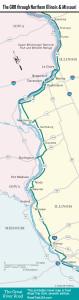
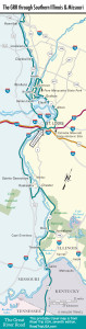
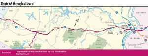
Travel Maps of the Great River Road and Missouri
Related Travel Guides