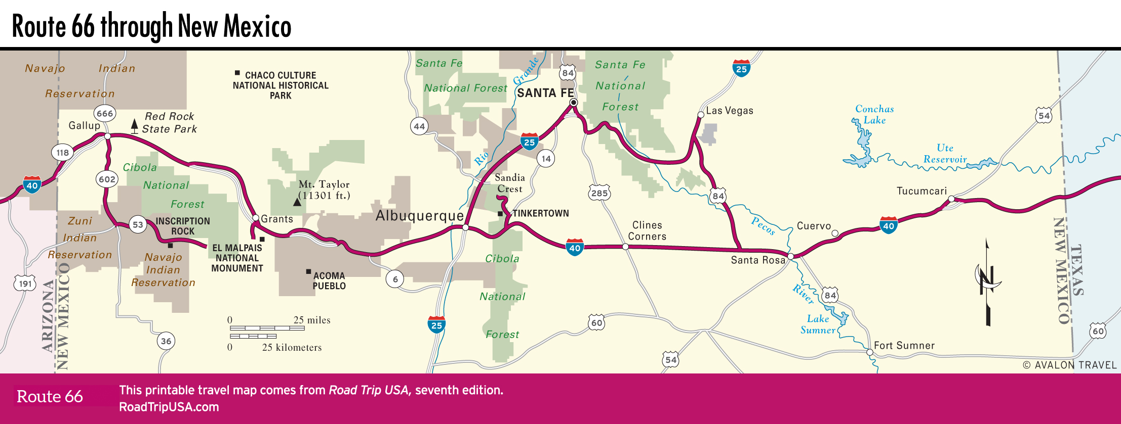
Albuquerque
Roughly located at the center of New Mexico, the sprawling city of Albuquerque (pop.560,218) spreads along the banks of the Rio Grande and east to the foothills of more than 10,000-ft Sandia Crest. By far the state’s biggest city, and in the spotlight as location of the TV show Breaking Bad, Albuquerque is a young, energetic, and vibrantly multicultural community, which, among many features, boasts a great stretch of old Route 66 along Central Avenue through the heart of the city—18 mi (29 km) of diners, motels, and sparkling neon signs.
One of the best parts of town is Old Town, the historic heart of Albuquerque. Located a block north of Central Avenue, at the west end of Route 66’s cruise through downtown, Old Town offers a quick taste of New Mexico’s Spanish colonial past, with a lovely old church, the 200-year-old San Felipe de Neri, as well as shops and restaurants set around a leafy green park. An information booth just off the park has maps of Old Town and other information about the city. Another Old Town attraction, one that carries on the Route 66 tradition of reptile farms and private zoos, is the American International Rattlesnake Museum (202 San Felipe St. NW, 505/242-6569, daily, $6), southeast of the main square, where you can see a range of rattlers from tiny babies to full-size diamondbacks, about 50 altogether, plus fellow desert-dwellers like tarantulas and a giant Gila monster.
A different look into New Mexico’s varied cultural makeup is offered at the Indian Pueblo Cultural Center (2401 12th St. NW, 505/843-7270, daily, $8.50), a block north of I-40 exit 158. The center is owned and operated by the state’s 19 different Pueblo communities. Its highlight is a fine museum tracing the history of the region’s Native American cultures, told by the Pueblo people (including in their native languages). It touches on the Indian School era, fitting given the center sits on formerly Indian school grounds. On most weekends ceremonial dances are held in the central courtyard, open to the general public. There’s also a restaurant where you can sample traditional food like fry bread and atole, and a gift shop with pueblo pottery and jewelry.
Downtown Albuquerque has been under reconstruction seemingly forever, with an ambitious mixed-use project surrounding the train station and massive old Santa Fe Railroad yards. Despite budget shortfalls, the state has pledged money for it, so someday the area may feature the enticingly named Wheels Museum (1100 2nd St. SW., 505/243-6269), tracing (surprise, surprise) transportation in New Mexico, inside the sprawling complex of train repair sheds.
Where to Eat and Stay in Albuquerque
The largest city in New Mexico, Albuquerque makes a handy point of entry for tours of the southwestern United States. For old road fans, the best stretch of Route 66 through Albuquerque is probably the section along Nob Hill, east of downtown near the University of New Mexico. Here you’ll find vintage neon and some great places to eat and drink, including Kelly’s Brew Pub (3222 Central Ave. NE, 505/262-2739), housed in a 1930s Streamline Moderne auto dealership, and the original Flying Star (3416 Central Ave. SE, 505/255-6633), famous for its desserts.
Between Nob Hill and downtown, the excellent 66 Diner (1405 Central Ave. NE, 505/247-1421) serves top-quality burgers and shakes, and regional specialties like green-chili chicken enchiladas. Perhaps the best breakfasts are at the super stylish Grove Café & Market (600 Central Ave. SE, 505/248-9800) in downtown’s Huning Highland Historic District.
Another good range of places to eat is within walking distance of Old Town, close to the Rio Grande. Enjoy a delicious mix of Mexican and American diner food at Garcia’s Kitchen (1736 Central Ave. SW, 505/842-0273), beneath a glorious neon sign. Fans of the TV show Breaking Bad may want to pay their respects to Walt and Jesse at the Dog House Drive In (1216 Central Ave. SW, 505/243-1019), which has a blinking neon sign that appeared in a number of episodes. Another old Route 66 landmark, Mac’s La Sierra (6217 Central Ave. NW, 505/836-1212), serves up steak fingers and other beefy specialties in a cozy dark-wood dining room a long ways west of town.
Like most of New Mexico, Albuquerque has a ton of inexpensive accommodations, with all the usual chain motels represented near the airport and along the interstate frontage roads, plus a lot of fading or extinguished old stars of the Route 66 era. The famous El Vado Motel (2500 W. Central Ave. SW) was built in 1937, listed on the National Register of Historic Places in 1993, and has been redeveloped by the city of Albuquerque as a dining and shopping destination. The same proprietors manage the Monterey Motel (2402 Central Ave. SW, 505/243-3554, $78 and up), near Old Town. The nicest hotel has got to be the grand old Hotel Andaluz (125 2nd St. NW, 505/242-9090, $140 and up), a block off old Route 66 in the heart of the lively downtown nightlife district. One of the first inns built by New Mexico-born hotel magnate Conrad Hilton, the Andaluz has been thoughtfully and completely restored and updated, and is now the most comfortable and gracious place to stay, with an entrancing second-story open-air bar.
Travel Map of New Mexico
Related Travel Guides