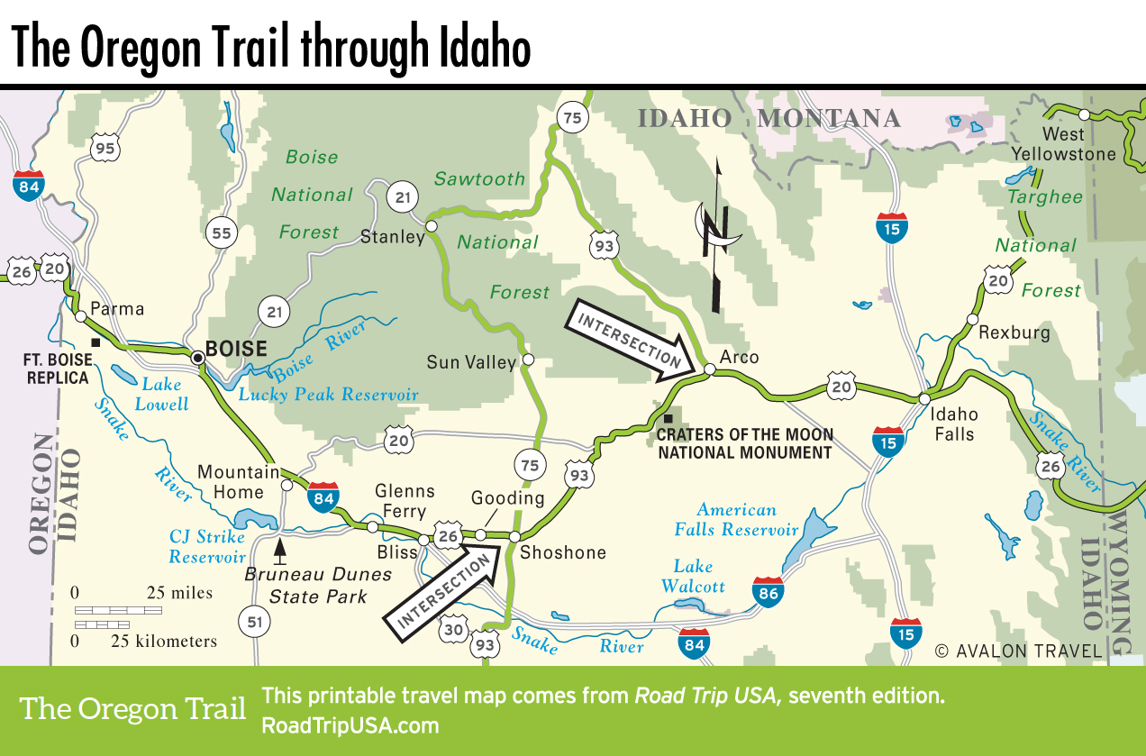
Bliss to Shoshone
Bliss
Along with providing the chance to add to your collection of city limits signs, or to send a postcard saying you’re in Bliss (pop. 306), this idyllically named town is worth a stop to see the deep canyon of Malad Gorge (208/837-4505, daily dawn-dusk, $4), well signed southeast of town, off I-84 exit 147. Now part of Thousand Springs State Park, it doesn’t look like much until you get out of the car and walk 100 ft (30 m) down the trail, where you suddenly come upon a truly awesome sight: a 250-ft-deep (76-m) gorge with a crashing waterfall. The freeway passes overhead, oblivious to the natural wonder directly below.
Hagerman Fossil Beds National Monument
Across the Snake River from Malad Gorge, Hagerman Fossil Beds National Monument contains what’s been called “the richest known deposit of Pliocene Age terrestrial fossils,” mainly horses (Equus simplicidens) that roamed the area some 3.5 million years ago. The undeveloped monument also preserves one of the longest sections of visible wagon ruts in the entire length of the Oregon Trail. The visitors center (208/933-4105) is in Hagerman, 10 mi (16.1 km) south of Bliss and across the river from the fossil beds. The center also has information on visiting the area’s other national park property: the Minidoka National Historic Site, north of Twin Falls.
US-26: Gooding and Shoshone
In the midst of inhospitable volcanic badlands, a pair of small towns that grew up along the railroad tracks have somehow survived to the present day. Coming from the west along US-26 from Bliss, the first one you reach is Gooding (pop. 3,473), named for local sheep rancher Frank Gooding, who went from being mayor to Idaho governor to U.S. senator before his death in 1928.
A straight shot east along the tracks brings you to Shoshone (pop. 1,511), another ranching and railroad center with a number of buildings that have been constructed from local volcanic rock. Though it’s a fairly timeworn place, Shoshone looks great at sunset, when its steel water tower glows and places like the neon-signed Manhattan Café (208/886-2142), along the railroad tracks, look especially appealing.
If you’re hungry, thirsty, or low on gas, be sure to fill up here, as services are rare between Shoshone and Arco, 82 mi (132 km) to the east.
Related Travel Guides