Bernalillo to Laguna Pueblo
Old Route 66: Bernalillo
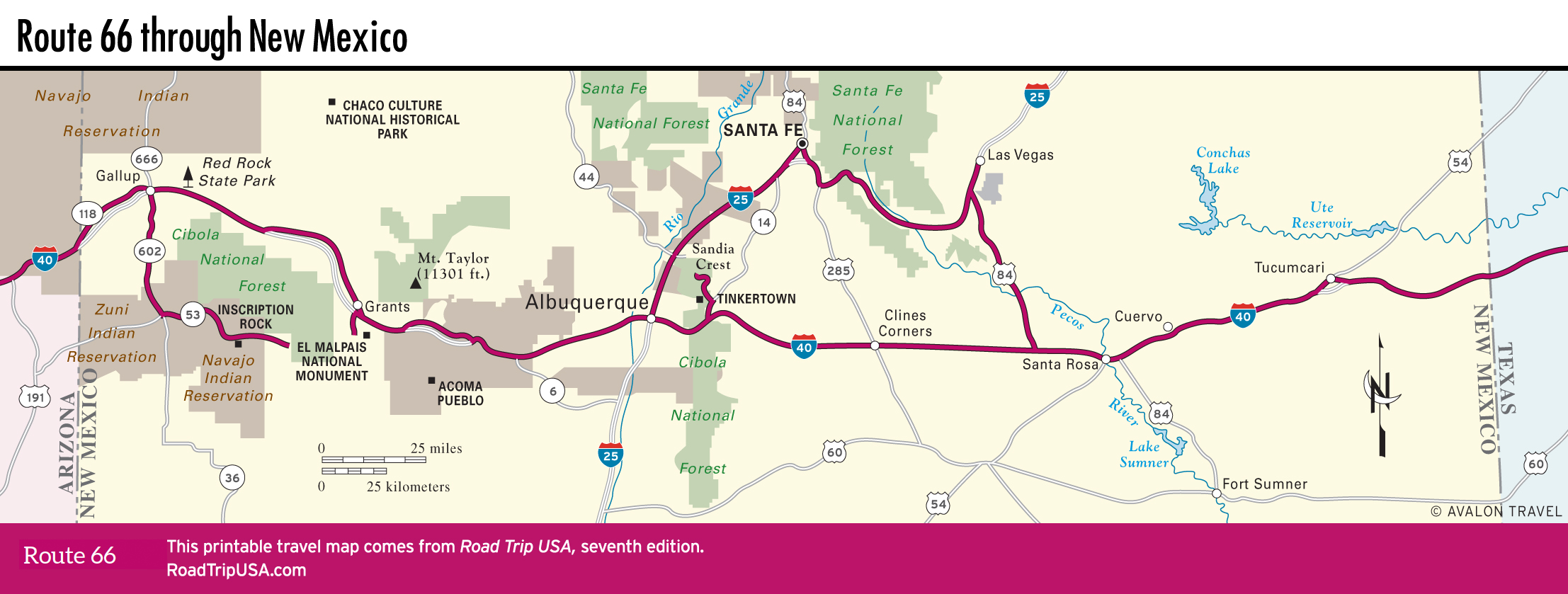
True fans of the full Route 66 tour, and anyone interested in the art and architecture (and food!) of the American Southwest, will want to make the trip to the state capital, Santa Fe. The original Route 66 alignment ran north from Albuquerque along the I-25 corridor through Las Vegas, then curved back south from Santa Fe along what’s now US-84, to rejoin I-40 west of Santa Rosa.
The best sense of this old route across old New Mexico comes just north of Albuquerque, at the historic town of Bernalillo. Route 66 here follows the much older El Camino Real, which linked these Spanish colonies more than 400 years ago. The heart of Bernalillo contains two great stops, poles apart from each other in ambience but together capturing the essence of the place. First of these is ancient-feeling Silva’s Saloon (955 S. Camino del Pueblo, 505/867-9976), its walls, coated in layers of newspaper clippings, old snapshots, and other mementos, forms a fabulously funky backdrop for a cold beer alongside cowboys, bikers, and other characters. Just up the street is the stylish Range Café (925 S. Camino del Pueblo, 505/867-1700), where a spacious dining room has good “New New Mexican” food (try the bread pudding!) and a sophisticated big-city air.
Laguna Pueblo
Between Albuquerque and Acoma Pueblo, a fine old stretch of old Route 66 survives, passing crumbling tourist courts and service stations across the Laguna Indian Reservation. The photogenic Route 66 highlight here is the graceful old steel truss Rio Puerco Bridge, which spans a usually dry river, right alongside I-40 about 15 mi (24 km) west of Albuquerque. The old-road ambience is also overwhelmed by the huge Route 66 Casino, south of the freeway, one of the largest of many gambling complexes that have sprung up on Native American reservations across this part of New Mexico. Besides the jinglingly huge 50,000-sq-ft (4,645-sq-m) casino, which has the usual card tables, craps, and roulette, the complex also has a 2,800-seat theater, a roadside café, a smoke shop offering cheap (tax-free) tobacco, and a large hotel (866/711-7829, $109 and up).
The heart of the historic Laguna Pueblo, where some 500 people live in adobe buildings around a church that dates from 1699, is not open to travelers, but just west of the pueblo the old Route 66 frontage runs past an old road landmark: Budville, where the remnants of an old trading post and café still stand in atmospheric silence along the north side of the highway.
Related Travel Guides

Travel Map of New Mexico