Lebanon and Mansfield
Lebanon
The stretch of old Route 66 running through Lebanon (pop. 14,807) holds more than its fair share of sights, so make sure you slow down and soak it all in. The most worthwhile but easiest-to-miss sight is the excellent Route 66 Museum (915 S. Jefferson St., 417/532-2148), tucked away inside the Lebanon-Laclede County Public Library, next door to the Ritz 8 Cineplex. Here the whole history of the U.S. highway systems is conveyed through maps, postcards, promotional posters, and life-size dioramas.
On the north side of I-44 lies the marvelous Munger Moss Motel (1336 E. Route 66, 417/532-3111, $45 and up), which opened in 1946. Current owner Ramona Lehman and family have been offering clean rooms, a swimming pool, and a wonderful neon sign here since 1971. Across from the Munger Moss is a bowling alley with a snack bar and a set of batting cages (5 cents a pitch!), making it a perfect Route 66 destination.
Follow Elm Street (old Route 66) east from downtown Lebanon, past the Munger Moss and along the north side of I-44, to two more highlights. On weekend nights, noisy NASCAR stock cars race around the asphalt oval of the Lebanon I-44 Speedway (417/532-2060, $12).
Mansfield
While the good food and warm Munger Moss hospitality is more than reason enough to visit Lebanon, the town also marks the turnoff for a trip to visit another American institution, the Ozark Mountain homestead where author Laura Ingalls Wilder wrote the famous Little House books. Though it’s an hour detour south via Hwy-5, or 52 mi (84 km) due east of Springfield via US-60, Wilder’s Rocky Ridge Farm has been preserved as the Laura Ingalls Wilder Historic Home and Museum (3060 Hwy-A, 877/924-7126, daily Mar.-Nov. 15, $15), on a hill a mile (1.6 km) southeast of the town of Mansfield. Unlike the many reconstructed Little House sights elsewhere, this museum has a direct and intimate connection with the woman who, for generations of readers, brought the American frontier to life.
Born in 1867, Wilder grew up with the country, her iconic “little house” moving ever westward from the “big woods” of Wisconsin on to the “prairie” of Kansas and South Dakota. Wilder moved to the Ozarks in 1894 and worked to establish a successful apple and dairy farm. It was not until the economic downturn of the 1930s, when Wilder was in her 60s, that she began publishing her books, which have since sold millions (some of the royalties go to support the Mansfield library, where there is also a small museum). The home the Wilders lived in most of their adult lives forms the heart of the museum. They are buried in the town cemetery, alongside their daughter Rose, who urged on (and some say collaborated on) Laura’s autobiographical stories.
Related Travel Guides


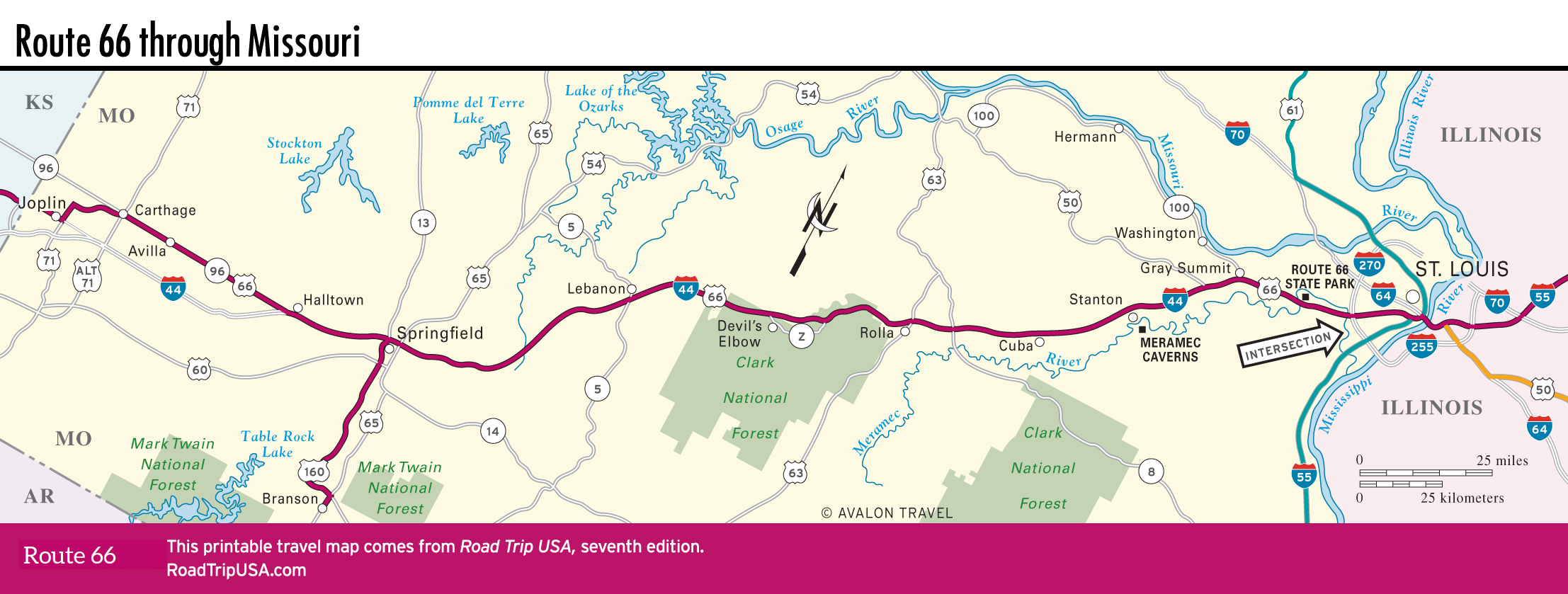
Missouri Travel Map