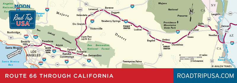
Mojave National Preserve and Bagdad Cafe
Mojave National Preserve
Spreading north of old Route 66, more than 1.6 million ac (645,500 ha) between I-40 and I-15 have been set aside as the Mojave National Preserve, a harsh desert landscape of volcanic cinder cones and sand dunes, desert tortoises, and Joshua trees. One evocative landmark here in the middle of the desert is the Kelso Depot (760/252-6100), a restored train station that sits on the main LA-to-Las Vegas Union Pacific Railroad line. Trains still rumble past, and the depot, featuring a variety of interpretive exhibits, recreates the sense of life here in the 1920s, before air conditioning and cell phones made life in the desert so much more agreeable. Kelso is on Kelbaker Road, about 22 mi (35 km) north of I-40, midway between Fenner and Ludlow.
Another of the many places in the Mojave Preserve that’s worth the trip is Mitchell Caverns (760/928-2586) at the center of Providence Mountains State Recreation Area, 20 mi (32 km) north of I-40 at the end of Essex Road.
Bagdad Cafe
Running alongside the I-40 freeway for about 50 mi (81 km) east of Barstow, old Route 66 survives as a sort of frontage road, passing little more than an occasional lava flow (like Pisgah Crater, where there’s a pair of I-40 rest areas).
About 20 mi (32 km) east of Barstow is the place that for many people symbolizes the quirky personality of Route 66: Newberry Springs. The cult classic Percy Adlon movie Bagdad Café was shot at the town’s one and only café, now also known as the Bagdad Café (760/257-3101). Considering its connections with the oddly endearing movie (which features a cast of drifters, a large German magician, and Jack Palance!), the real-life Bagdad Café (760/257-3101) is welcoming and appropriately weird, not so much a restaurant as it is a semi-catered film set. It stays in business as a pit stop for fans of offbeat European cinema who happen to find themselves in the middle of the Mojave Desert. Be sure to read and sign the guest book, which features heartfelt comments from hundreds of people who’ve made the trek here from all over the world; Scandinavians and Teutonic types seem especially well represented.
Between the Bagdad Café and Barstow, old Route 66 runs past the region’s other unique claim to fame: The semi-successful Solar One power plant, an experimental 64-megawatt electricity generating station north of I-40, was built in the 1980s and is now used as an astronomical gamma-ray observatory. If you like shiny cutting-edge technology, you may want to detour from Barstow to Las Vegas along I-15 to see the nearly 400-megawatt Ivanpah Solar Power Facility, one of the world’s largest solar thermal plant, which is clearly visible from the freeway.
Related Travel Guides

California Travel Map