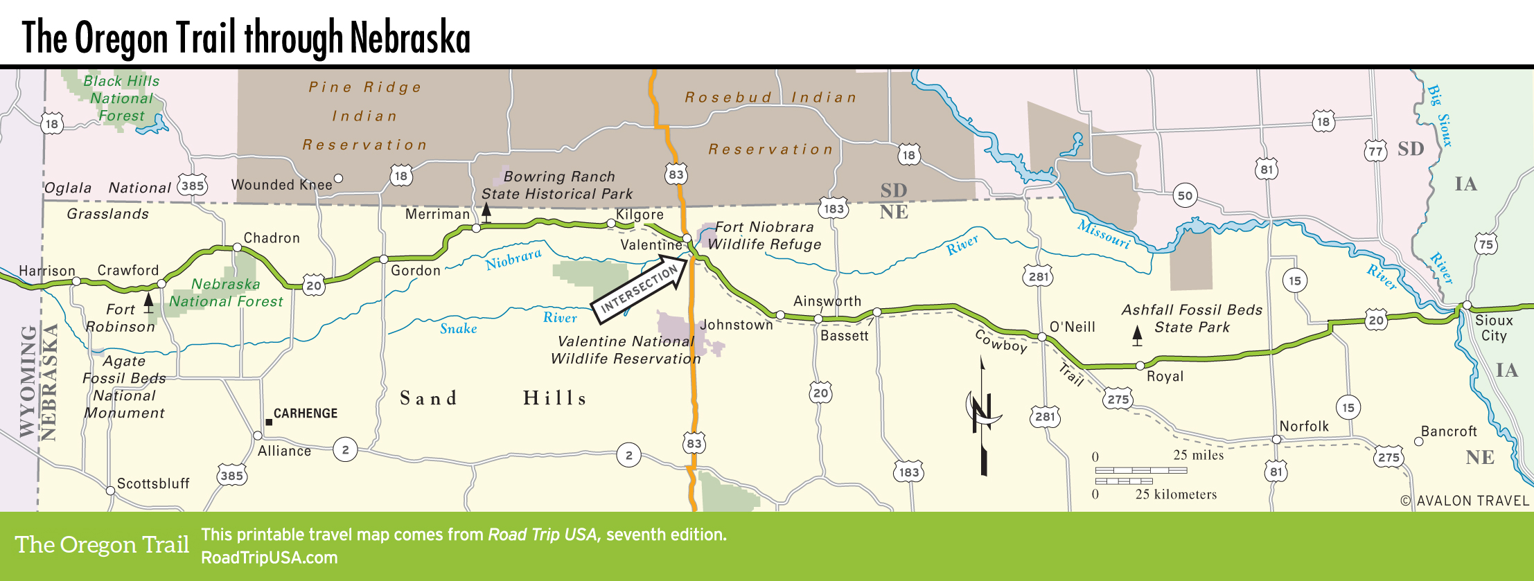
Mt. Rushmore to Johnstown
US-385 Monuments
Three of the nation’s most distinctive outdoor sculptures stand along US-385 within a manageable drive from US-20. One is perhaps the best-known artwork in the United States: the giant presidential memorial at Mt. Rushmore. Roughly 100 mi (161 km) north from Chadron, at the far eastern side of the beautiful Black Hills, Mt. Rushmore is graced by the 60-ft (18-m) heads of four U.S. Presidents—Washington, Jefferson, Lincoln, and Teddy Roosevelt—carved into a granite peak. It’s equal parts impressive monument and kitschy Americana, and one of those places you really have to see to believe.
On the way to Mt. Rushmore, be sure to stop and see the ambitious Crazy Horse Memorial, the world’s largest work-in-progress, 5 mi (8 km) north of Custer, South Dakota, along US-385. When completed, Crazy Horse will be 563 ft (172 m) tall and 641 ft (195 m) long—10 times the size of Mt. Rushmore. For now, it’s worth a visit for the panoramic views over the Black Hills.
Another newer, less-famous monument to America sits in a flat field off US-385, outside the town of Alliance, 55 mi (89 km) south of Chadron. Built in 1987 as part of a local family reunion, Carhenge is a giant replica of the famous ruins of Stonehenge; this one, however, is built entirely out of three dozen American cars, stacked on top of one another to form a semicircular temple.
Merriman
East of Chadron, US-20 winds along the northern edge of the Sand Hills, coming within a few miles of the South Dakota border. The town of Merriman (pop. 129) may not look like much, but it does mark the turnoff north to the nearby Bowring Ranch State Historical Park (308/684-3428, Thurs.-Tues. summer, $2), a working cattle ranch preserved pretty much as it was at the turn of the 20th century. The site is lovely, with a sod house surrounded (in springtime, at least) by rolling green hills. A modern visitors center has displays on windmills and other facts of Sand Hills life, plus biographical displays on the politically powerful Bowring family, who lived and worked here from 1895 until 1985. To get there, head 1.3 mi (2 km) north of town on Hwy-61, then 2 mi (3.2 km) northeast following good signs.
Between Merriman and Valentine, US-20 passes through flyspeck former railroad towns including Cody (pop. 154), Kilgore (pop. 79) and Crookston (pop. 70). Kilgore marks the dividing line between central and mountain time zones; adjust your clocks and watches accordingly.
Johnstown
In the village of Johnstown (pop. 60), 35 mi (56 km) southeast of Valentine and 10 mi (16.1 km) west of Ainsworth, a block of wooden storefronts and boardwalks was gussied up as a backdrop for a TV production of Willa Cather’s O Pioneers! Behind the contrived facades you’ll find a dusty old general store and a beer bar and pool hall complete with a backyard privy.
Off Norden Road, 17 mi (27 km) north of Johnstown, the Nature Conservancy protects the nearly 56,000-acre (22,700 hectares) Niobrara Valley Preserve (402/722-4440), which has both sand hills and riparian ecosystems stretching west to the Niobrara reserve on the outskirts of Valentine. Self-guided trails wind through the preserve past a slowly expanding herd of some 500 bison, and early spring sees the annual migration of sandhill cranes, some 500,000 of whom rest here and at sites along the North Platte River before continuing north to Canada.
Related Travel Guides