Castle Gate to Price
Castle Gate
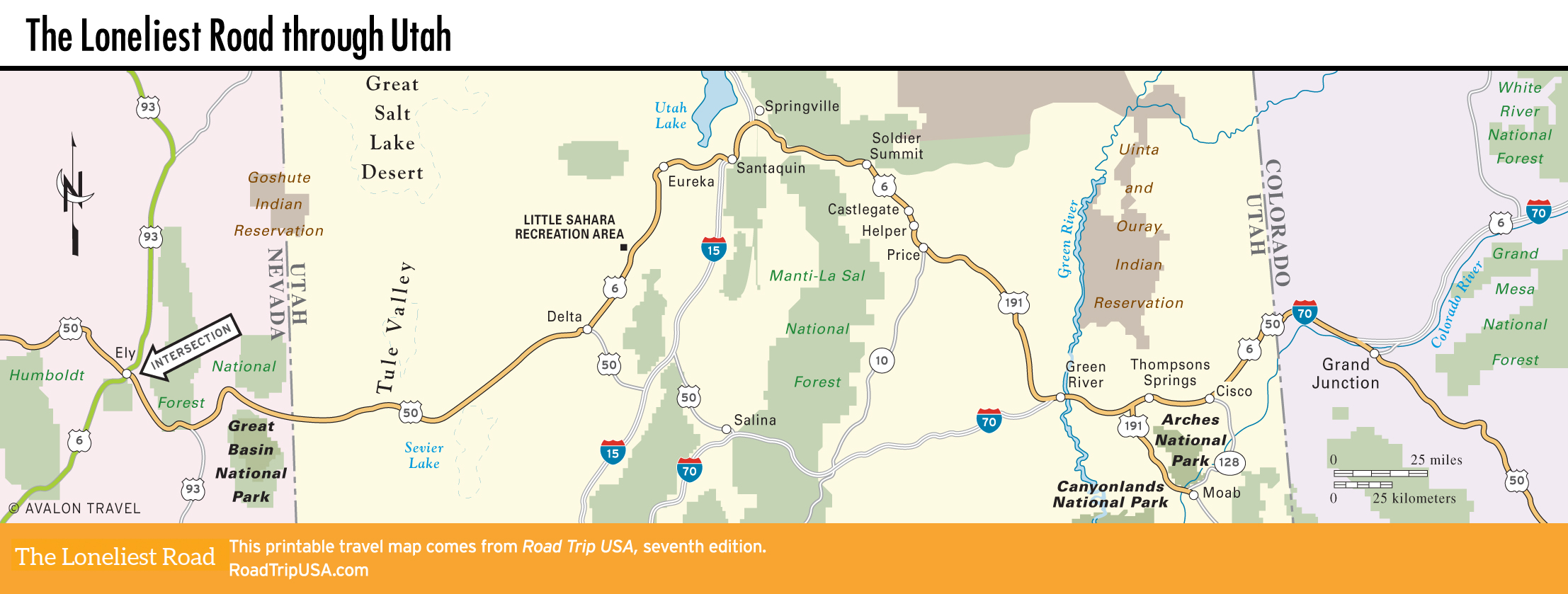
Heading east from Springville, the drive along US-6 (old US-50) up and over 7,477-ft (2,279-m) Soldier Summit is truly beautiful, as the two-lane highway twists alongside pines and cottonwoods to the crest, then passes through bright red sandstone canyons along the stark eastern side of the towering Wasatch Mountains. Dropping down from Soldier Summit, US-6/191 winds along the Price River through Castle Gate, a steeply walled sandstone canyon lined with working coal mines, many of which you see from the highway. While most now rely on heavy machinery to do the dirty work of digging out the coal, the Castle Gate area has been the site of the two worst mining disasters in Utah history: 171 men and boys killed in a 1924 explosion, and 200 killed at nearby Scofield on May Day, 1900.
Helper
Tiny Helper (pop. 2,091), at the downstream edge of Castle Gate, 7 mi (11.3 km) northwest of Price, is a classic railroad town preserved almost unchanged for nearly a century. Helper earned its name in 1892 when the Denver and Rio Grande Railroad built a depot and roundhouse here to hold the “helper” engines that were added to trains to help push them over Soldier Summit, 23 mi (37 km) to the west. The six-block downtown area, fronting onto the tracks, includes so many turn-of-the-20th-century brick- and stone-fronted buildings that it’s been declared a National Historic District—although the sad truth is that most of these have stood abandoned since the railroad switched to diesel power in the 1950s.
Relive the glory days at the excellent Western Mining & Railroad Museum (294 S. Main St., 435/472-3009, Tues.-Sat. winter, Mon.-Sat. summer, donation), which contains enough raw material on railroading and coal mining, not to mention the region’s diverse immigrant cultures, to keep you occupied for an hour or more. There’s also a display recounting the exploits of Butch Cassidy and his gang, who raided banks and rustled cattle throughout the region in the late 1890s, hiding out in the surrounding hills. Behind the museum, an outdoor lot displays some of the giant machines used in the coal mines, which, unlike the railroad, still employ a large number of local people.
Price
The largest city in eastern Utah, Price (pop. 8,232) is located roughly midway between the I-15 and I-70 freeways, 65 mi (105 km) northwest of Green River. Coal is so prevalent in the area that road cuts reveal solid black seams, but the town itself is lush and green thanks to irrigation provided by the Price River, which flows south from town into the Green and Colorado Rivers.
Coal mining and, to a lesser extent, agriculture still power Price, where the kid-friendly Utah State University Eastern Prehistoric Museum (155 E. Main St., 435/613-5060, 9am-5pm Mon.-Sat., $6) is worth a look for its extensive displays on the Native American cultures of the region, and for its range of full-size dinosaur skeletons, including a stegosaur and a Utahraptor. Many of these were reassembled from fossils collected from the Cleveland-Lloyd Dinosaur Quarry, 30 mi (48 km) south of town.
Price also has all the highway services travelers might need: numerous gas stations, places to eat, and nine motels, including the nice Quality Inn (435/637-5660, $64 and up).
Southwest from Price, bound for Green River and the I-70 freeway, US-6/191 runs alongside the busy Denver and Rio Grande main-line railroad through a region of arid plateaus highlighted every few miles by brilliantly colorful, weirdly sculpted sandstone mesas. Though barren and empty at first glance, the region is particularly rich in two things: coal mines and, more unusually, dinosaur bones. (Why do you think they call them fossil fuels?)
Related Travel Guides