Picacho Peak to Biosphere 2
Picacho Peak
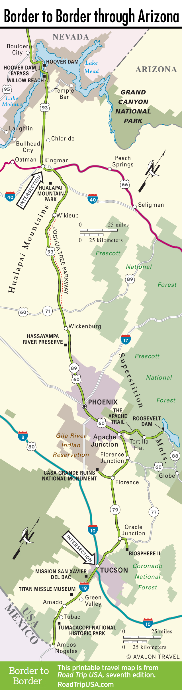
Looming like a giant battleship alongside the I-10 “fast road,” 75 miles southeast of Phoenix and 45 miles northwest of Tucson, 3,374-foot Picacho Peak has served as a Sonora Desert landmark for as long as there have been people here. Native Americans, Spanish explorers, American pioneers, you name it—they’ve all used the volcanic peak to keep them on track. Now a state park (520/466-3183, $3 per person or bike, $7 per car), Picacho Peak also played a role in the Civil War; the official westernmost battle of the War Between the States was fought here on April 15, 1862, when a dozen Union soldiers skirmished with 17 Confederate cavalrymen. These days, people come here to enjoy the saguaro cactus and the desert wildflowers (mainly in March, when they’re at their most colorful), or to hike to the summit for a desert panorama (two miles each way, with roughly 1,500-foot elevation gain). The park is open for day use and camping.
Along the freeway at the foot of Picacho Peak, the sprawling Rooster Cogburn Ostrich Ranch ($10 and up) lets you feed the ungainly beasts or purchase a variety of ostrich-derived products. There’s also a petting zoo and the unusual chance to take a tour, riding in the back of a massive 4WD “Monster Truck.”
Florence
If you have enough time to avoid the I-10 freeway and follow a slower but more scenic older road, consider Hwy-79, which cuts off south from Apache Junction and US-60. The first stop is Florence, one of Arizona’s oldest towns, but now best known as the site of the state’s largest prison. Florence has a pleasant nontouristy Main Street of bars, general stores, and junk shops, parallel to and a half mile west of the highway. The penal history is documented in gruesome detail at the Pinal County Historical Museum (715 S. Main St., 520/868-4382, Sept.-July 15 Tues.-Sat. 11am-4pm, Sun. noon-4pm, donation), where an actual hangman’s noose and chairs from the retired gas chamber are displayed along with photos of people put to death.
Casa Grande Ruins National Monument
West of Florence, some of the state’s largest and most perplexing prehistoric remains are preserved in the Casa Grande Ruins National Monument (520/723-3172, daily, $5), off Hwy-287 midway between Florence and I-10. A small visitors center at the entrance gives some background on the Hohokam people, who built the four-story “big house” and the surrounding village, but no one knows what it was used for or why it was abandoned.
Biosphere 2
One of the most ambitious, controversial, and just plain bizarre schemes to hatch at the millennial end of the 20th century was Biosphere 2, which stands in the Arizona desert at the northern foot of snowcapped Mt. Lemmon. Developed in the 1990s by a New Age group called Synergia Ranch and funded (to the tune of $200 million) by Texas billionaire Ed Bass, Biosphere 2 was originally intended to simulate the earth’s entire ecosystem in order to test the possibility of building self-sustaining colonies on other planets. A crew of four “biospherians” spent two not entirely self-sustained years sealed inside, but amid allegations of corruption and deceit, the project imploded. The University of Arizona eventually took over running the domes, and has since redirected the focus onto research into the effects of greenhouse gases and other ecosystem changes. The surrounding land has been sold and is slated to become yet another upscale housing development, but Biosphere 2 itself should stay open for self-guided tours (520/838-6200, daily, $20, kids under 5 free). To reach Biosphere 2, follow Hwy-79 to Oracle Junction, 25 miles north of Tucson, then turn east onto Hwy-77 for 6 miles and follow the signs.
Related Travel Guides


Travel Map of the Border to Border Route Through Arizona