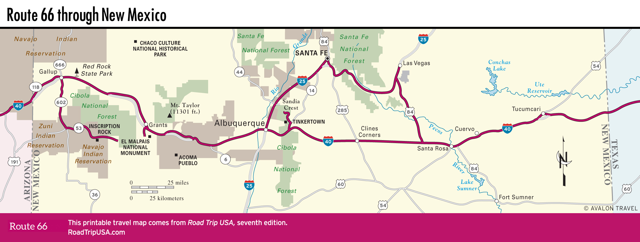
Grants and Hwy-53
Grants
Along with the usual Route 66 range of funky motels and rusty neon signs, the former mining boomtown of Grants (pop. 8,968) has the unique attraction of the New Mexico Mining Museum (505/287-4802, Mon.-Sat., $8), right downtown on old Route 66 (Santa Fe Avenue) at the corner of Iron Avenue. Most of the exhibits trace the short history of local uranium mining, which began in 1950 when a local Navajo rancher, Paddy Martinez, discovered an odd yellow rock that turned out to be high-grade uranium ore. Mines around Grants once produced half the ore mined in the United States, but production has ceased, pending renewed interest in nuclear power. From the main gallery, ride the elevator down (only one floor, but it feels like 900 ft/274 m) to the highlight of the mining museum: a credible re-creation of a uranium mine, complete with an underground lunch room emblazoned with all manner of warning signs.
The landmark Uranium Café, with its atomic neon sign across Route 66 from the mining museum, has been going in and out of business for years.
Hwy-53: El Malpais and Inscription Rock
Western New Mexico is among the most beautiful places on the planet. South of I-40 and Route 66, one of the best drives through it, Hwy-53, loops between Gallup and Grants across the Zuni and Navajo Nation reservations. Hwy-53 skirts the southern foothills of the more than 9,000-ft (2,743-m) Zuni Mountains, along the edge of the massive El Malpais National Monument lava flow—thousands of acres of pitch-black, concrete-hard, glassy sharp rock sliced and diced by lava tubes and collapsing craters. Formed between 10,000 and 115,000 years ago, most of the Malpais is wild and undeveloped, but on the slopes of Bandera Volcano, you can tour the privately run Ice Cave (888/423-2283, daily, $12), where the cool temperatures are welcome on a hot summer’s day.
West from El Malpais, the route follows ancient Native American trails that Coronado used on his ill-fated 1540 explorations, winding past piñon-covered hills, open grasslands, and the fascinating graffiti collection of El Morro National Monument. The 200-ft-high (61-m) sandstone cliffs of El Morro, the most famous of which is Inscription Rock, have been inscribed by travelers like Juan de Oñate, who wrote his name with a flourish in 1605, after he “discovered” the Gulf of California.
Atop the cliffs are the partially excavated remains of a small pueblo dating from around AD 1200. A 2-mi (3.2-km) loop trail to the inscriptions and the ruins starts from a small visitors center (505/783-4226, ext. 801, daily, free), where exhibits outline the history of the site. The trails are closed an hour before sunset, so get here early enough in the day to enjoy the beautiful scenery. There is also a small campground (no showers; pit toilets) amid the junipers.
Southwest of Inscription Rock, animal lovers may want to visit the Wild Spirit Wolf Sanctuary (505/775-3304, Tues.-Sun., $10 and up), where more than three dozen wolves and wolf-dogs live on a 100-year-old moonshiner’s ranch.
Related Travel Guides

Travel Map of New Mexico