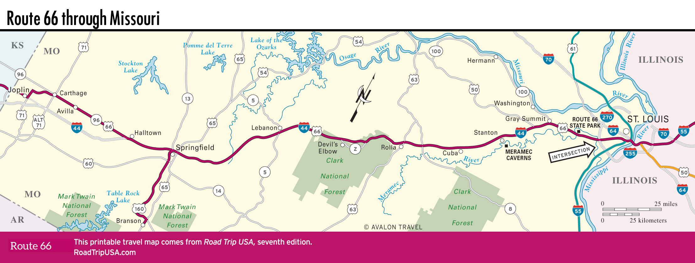
St. Louis to Gray Summit
St. Louis
It can be maddening to follow old Route 66 across St. Louis, but its many great spots—Ted Drewes Frozen Custard stand, in particular—make it well worth the effort. One route crossed the Mississippi River right into downtown from Collinsville, Illinois, while another “City 66” route headed across the Chain of Rocks Bridge before running into downtown St. Louis along Florissant Avenue and Riverview Drive.
Heading southwest out of downtown, the old road followed Gravois Avenue, Chippewa Street, and Watson Road, just south of the parallel I-44 freeway.
Times Beach: Route 66 State Park
There’s no plaque or notice proudly marking the spot, but the story of Times Beach (pop. 0) deserves mention. Founded in the 1920s as a weekend getaway a dozen mi (19.3 km) west of St. Louis along the Meramec River, the town grew into a working- class commuter suburb of some 2,000 people, thanks to Route 66. But there were no paved streets except for the not-yet-famous highway that passed through the center of town. Times Beach remained a quiet hamlet until 1982, when the federal government discovered that the industrial oil sprayed on streets to keep down dust had in fact been contaminated with toxic dioxin. The toxic waste, combined with a Meramec River flood that buried the town for over a week, made Times Beach uninhabitable.
In 1983 the government paid $33 million to buy Times Beach and tear it down, and 15 years later the cleanup was declared complete. The 419 ac (170 ha) of what was once Times Beach have since been reopened as the Route 66 State Park (636/938-7198, daily, free), north of I-44 exits 265 and 266, with hiking trails, river access, and a nice little museum on Times Beach and Route 66, housed in a 1930s roadhouse.
I-44: Eureka and Gray Summit
Heading south and west out of St. Louis, the I-44 freeway has pretty well obliterated old Route 66 as far as Eureka, where the sprawling amusement park Six Flags St. Louis (636/938-5300, around $70) effectively marks the city’s suburban edge. The park has all the thrill rides and water park fun you could want, and often hosts concerts and special events.
A different experience can be had in the town of Gray Summit, just west of Six Flags, at the magical Shaw Nature Reserve (636/577-9555, daily, $14), a 2,400-ac (971-ha) semi-wilderness of native plants, cultivated orchards, and wildflower meadows, just 40 mi (64 km) from the Gateway Arch. It’s tended by the Missouri Botanical Garden. If you like animals, especially dogs and cats, you’ll want to check out the well-trained pets showcased across I-44 at Purina Farms (314/982-3232, Tues.-Sun. May-Aug., Wed.-Mon. Mar.-Apr. and Sept.-Nov., free). Dogs catch Frisbees and do all sorts of amazing tricks, while cats sit there and look pretty.
Between Six Flags and the Shaw Nature Reserve, Route 66 reemerges from the shadows of I-44, winding through the hamlet of Pacific. West of Pacific, Route 66 climbs toward Gray Summit past the faded old Route 66 sign for the shuttered Diamonds Truck Stop and long-gone Gardenway Motel.
For most of the 30 mi (48 km) between Gray Summit and Meramec Caverns, old Route 66 is overwhelmed by the I-44 freeway, so most Route 66 aficionados opt for the freeway and save their exploring for better stretches, like Devil’s Elbow.
Missouri Travel Map
Related Travel Guides