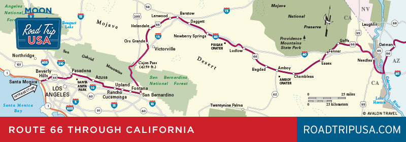
San Gabriel Valley
Though it’s now effectively swallowed up in Southern California’s never-ending sprawl, the San Gabriel Valley used to be the westbound traveler’s first taste of Southern California. After crossing the Mojave Desert and the high mountains, Route 66 dropped down into what might have seemed like paradise: orange groves as far as the eye could see, a few tidy towns linked by streetcars, and houses draped in climbing roses and bougainvillea. The valley takes its name from old Mission San Gabriel Arcángel (428 S. Mission Dr., 626/457-3035, Mon.-Sat. 9am-4:30pm, Sun. 10am-4pm, $6), which still stands. Despite suffering extensive earthquake damage, the mission is an interesting spot, though not as evocative as others in the chain.
Winding between Pasadena and San Bernardino, along the foothills of the sometimes snowcapped San Gabriel Mountains, old Route 66 links a number of once-distinct communities. In Upland, where the old road features a number of recently installed retro-Route 66 streetlamps, there’s a grass median strip graced by one of the 12 Madonna of the Trail statues, which officially marked the western end of the National Old Trails Highway, the immediate precursor to Route 66. Glendora is home to a great old-fashioned 24-hour doughnut shop, the Donut Man (915 E. Route 66, 626/335-9111), while Azusa is home of the classic Foothill Drive-In, whose marquee was saved when the land was developed as a college campus.
The city of Monrovia (pop. 37,126) holds another Route 66 survivor: the Aztec Hotel (311 W. Foothill Blvd., 626/358-3231), known more for its groovy Mesoamerican-style art deco exuberance than for its rooms, but well worth a look. Monrovia was home for many years to quixotic author Upton Sinclair (1878-1968) and is now the headquarters of the cult-favorite grocery store Trader Joe’s. The company, which started in 1958 as Pronto Markets and is now owned by the transnational corporation Aldi, opened its first Trader Joe’s store in Pasadena in 1967.
In the next town to the west, Sierra Madre, Foothill Boulevard runs past the landmark racetrack at Santa Anita, designed by Hoover Dam stylist Gordon Kaufmann. Sadly, the art deco facades have been ruined by the track’s ongoing “development” into a Las Vegas-scale gaming and shopping complex. Two notable moments in history occurred here, one whimsical, the other much darker. In 1937 the Marx Brothers filmed A Day at the Races here. Just five years later, Santa Anita served as an assembly center for Japanese Americans en route to internment camps after U.S. entry into World War II.
Related Travel Guides

California Travel Map