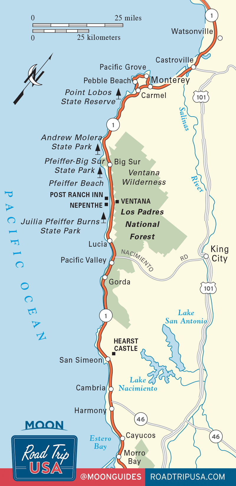
Big Sur
Big Sur Village
South of Andrew Molera, Hwy-1 cuts inland toward the heart of Big Sur, the deep and densely forested valley carved by the Big Sur River. Consisting of little more than three gas stations, a couple of roadside markets, and a number of lodges and restaurants, the mile-long village of Big Sur (pop. 1,463) represents the only real settlement between Carmel and Hearst Castle.
At the north end of town, the Big Sur River Inn (831/667-2700, $150 and up) has a woodsy, warm, and unpretentious restaurant overlooking the river, and rooms upstairs and across the highway. Next door is a small complex that includes crafts galleries and a grocery store with a burrito bar. Continuing south, the next mile of Hwy-1 holds Big Sur’s nicest group of rustic cabins and campgrounds: Besides a handful of quaint cabins in a quiet location, downhill from the highway and right on the riverbanks, Ripplewood Resort (831/667-2242) also has a friendly café on the east side of Hwy-1, serving good breakfasts and lunches, as well as a handy gas station and general store.
At the south end of the Big Sur village, a classic 1950s motor court has been updated and restored to its vintage glory (now with free Wi-Fi) as Glen Oaks Big Sur (831/667-2105, $225 and up).
Pfeiffer Big Sur State Park
Roughly a half mile south of Big Sur village, Pfeiffer Big Sur State Park is the region’s main event, a 1,000-acre riverside forest that’s one of the most pleasant and popular parks in the state. Besides offering a full range of visitor services—a restaurant, a lodge, a riverside campground, and a grocery store—the park includes one of Big Sur’s best short hikes, a three-mile loop on the Valley View trail that takes in stately redwoods, a 60-foot waterfall, and a grand vista down the Big Sur valley to the coast. The park also has the main ranger station (831/667-2315) for all the state parks in the Big Sur area. Just south of the park entrance, a U.S. Forest Service ranger station (831/667-2423) on the east side of Hwy-1 has information on hiking and camping opportunities in the mountains above Big Sur, including the isolated (but poison oak-ridden) Ventana Wilderness.
Pfeiffer Beach
South of Pfeiffer Big Sur State Park, halfway up a long steep incline, a small road turns west and leads down through dark and heavily overgrown Sycamore Canyon, eventually winding up at Big Sur’s best beach, Pfeiffer Beach. From the lot at the end of the road, a short trail runs through a grove of trees before opening onto the broad white sands, loomed over by a pair of hulking offshore rocks. The water is way too cold for swimming, but the half-mile strand is one of the few places in Big Sur where you can enjoy extended beachcombing strolls. The beach’s northern half attracts a clothing-optional crew, even on cool gray days.
Back along Hwy-1, just south of the turnoff for Sycamore Canyon and Pfeiffer Beach, the excellent Big Sur Bakery & Restaurant (831/667-0520) makes its own fresh breads and pastries, brews a rich cup of coffee, and also serves full meals—soups, steaks, and wood-fired pizzas.
Julia Pfeiffer Burns State Park
If for some untenable reason you only have time to stop once along the Big Sur coast, Julia Pfeiffer Burns State Park (daily dawn-dusk) should be the place. Spreading along both sides of Hwy-1, about 14 miles south of Big Sur village, the park includes one truly beautiful sight: a slender waterfall that drops crisply down into a nearly circular turquoise-blue cove. This is the only major waterfall in California that plunges directly into the Pacific. California Condors can be seen here too.
From the parking area, east of the highway, a short trail leads under the road to a fine view of the waterfall, while another leads to the remnants of a pioneer mill, complete with a preserved Pelton wheel. Other routes climb through redwood groves up to the chaparral-covered slopes of the Santa Lucia Mountains.
About six miles south of Nepenthe, or a mile north of the parking area at Julia Pfeiffer Burns State Park, a steep fire road drops down to Partington Cove, where ships used to moor in the protected anchorage. The last stretch of the route passes through a 60-foot-long tunnel hewn out of solid rock.
Spas and Resorts in Big Sur
South of Sycamore Canyon, roughly three miles from the heart of Big Sur village, Hwy-1 passes between two of California’s most deluxe small resorts. The larger of the two, Ventana Inn & Spa (831/667-2331 or 800/628-6500, $600 and up), covers 243 acres of Big Sur foothills and offers saunas, swimming pools, and four-star accommodations in 1970s-style cedar-paneled rooms and cabins. There’s also a fine restaurant, with incredible views and reasonable prices, to which guests are ferried in a fleet of electric carts.
Completed in 1992 and directly across Hwy-1 from Ventana, the Post Ranch Inn (831/667-2200 or 800/527-2200, $925 and up), a low-impact but ultra-high-style luxury resort hanging high above the Big Sur coast, is at the forefront of luxury ecotourism. In order to preserve Big Sur’s untarnished natural beauty, the Post Ranch Inn is designed to be virtually invisible from land or sea. The 39 guest rooms and one private house—all featuring a king-size bed and a whirlpool bath with built-in massage table—blend in with the landscape, disguised either as playful tree houses raised up in the branches of the oaks and pines or as underground cabins carved into the cliff top. The Post Ranch restaurant, Sierra Mar, is also excellent.
One of the most popular and long-lived stopping points along the Big Sur coast, Nepenthe (831/667-2345) is a rustic bar and restaurant offering good food and great views from atop a rocky headland some thousand feet above the Pacific. Named for the mythical drug that causes one to forget all sorrows, Nepenthe looks like something out of a 1960s James Bond movie, built of huge boulders and walls of plate glass. The food is plenty good—burgers, steaks, and only two fish dishes dominate the menu—but it’s the view you come here for.
Sharing a parking lot, and taking advantage of similar views, the neighboring Café Kevah (831/667-2345) serves brunch all day, plus good teas and coffees and microbrews on a rooftop deck. You’ll find a gift shop downstairs selling top-quality arts and crafts and knitwear by Kaffe Fassett, whose family owns the place.
Right along Hwy-1, at a sharp bend in the road just south of Nepenthe, The Henry Miller Memorial Library (831/667-2574, Wed.-Mon.) carries an erratic but engaging collection of books by and about the author, who lived in Big Sur for many years in the 1950s.
A half mile south of Nepenthe on the east side of the highway, one of the oldest and most atmospheric places to stay is Deetjen’s Big Sur Inn (831/667-2377, $115 and up), a rambling and rustic redwood lodge built by a Norwegian immigrant in the 1930s and now a nonprofit preservationist operation. Though the rooms are not available to families with young children unless you reserve both rooms of a two-room building, Deetjen’s also serves Big Sur’s best breakfasts and hearty dinners, at which all are welcome.
The New Age Esalen Institute (888/837-2536), three miles south of Julia Pfeiffer Burns State Park, takes its name from the Esselen Native Americans who were wiped out by European colonizers. Founded in the early 1960s by free-thinking Stanford University graduates inspired by countercultural pioneers like Gregory Bateson and Alan Watts, and set on a breathtaking cliff-top site overlooking a 180-degree coastal panorama, Esalen offers a variety of religious, philosophical, and psychological workshops, but most visitors are drawn to its incredible set of natural hot springs (open to the public 1am-3am, $35 per person, reservations required), right above the ocean. Call for information on overnight “personal retreats,” or to make reservations for massages or the hot tubs.
The southern reaches of the Big Sur coast are drier and more rugged, offering bigger vistas but fewer stopping places than the northern half. The road winds along the cliffs, slowing down every 10 miles or so for each of three gas station-café-motel complexes, which pass for towns on the otherwise uninhabited coast. The northernmost of these, 9 miles south of Esalen and 25 miles south of Big Sur village, is Lucia Lodge (831/667-2708 or 866/424-4787, $175 and up), which has wonderful ocean views, a small restaurant, and 10 creaky cabins.
High on a hill just south of Lucia, marked by a slender black cross, the Benedictine New Camaldoli Hermitage (831/667-2456, $135 and up) is open to interested outsiders as a silent retreat. Rates include private rooms and veggie meals. The mix of contemplative solitude and natural beauty is hard to beat.
Big Sur Travel Map
Related Travel Guides