Point Reyes
Valley Ford
Between Bodega Bay and Point Reyes, Hwy-1 veers inland to avoid the marshy lowlands, and midway between the two bigger destinations, the winding two-lane highway brings you to a great road-trip stop. Valley Ford is a photogenic community that holds a great old family-run roadhouse, Dinucci’s Restaurant (707/876-3260, dinner only Thurs.-Mon., lunch on weekends, $10-28 per person), serving huge portions of unreconstructed Italian food—minestrone, fresh bread, salad, and pasta.
More self-consciously stylish, contemporary fare is on the menu next door at quirky Rocker Oysterfeller’s Kitchen + Saloon (707/876-1983, dinner Thurs.-Fri., late lunch and dinner Sat., brunch and dinner Sun.), inside the Civil War-era Valley Ford Hotel, which has been renovated with luxurious rooms while retaining old-time charm (quilts on the beds, rocking chairs on the porch, the whole nine yards).
Point Reyes
Along this section of the Northern California Coast Hwy-1 slices through one of the country’s most scenically and economically wealthy areas, Marin County. Though less than an hour from San Francisco, the northwestern reaches of the county are surprisingly rural, consisting of rolling dairylands and a few untouched small towns; Hwy-1 follows a slow and curving route along the usually uncrowded two-lane blacktop.
After looping inland south of Bodega Bay, Hwy-1 reaches the shore again at oyster-rich Tomales Bay, around which it winds for a dozen or so miles before reaching the earthy but erudite town of Point Reyes Station. Here the excellent Station House Café (11180 Hwy-1, 415/663-1515, Thurs.-Tues.) serves incredibly good breakfasts and delicious lunches that include great-tasting local oysters, on the half-shell or barbecued. The bar is lively and well stocked, and it hosts free live music most Sunday afternoons.
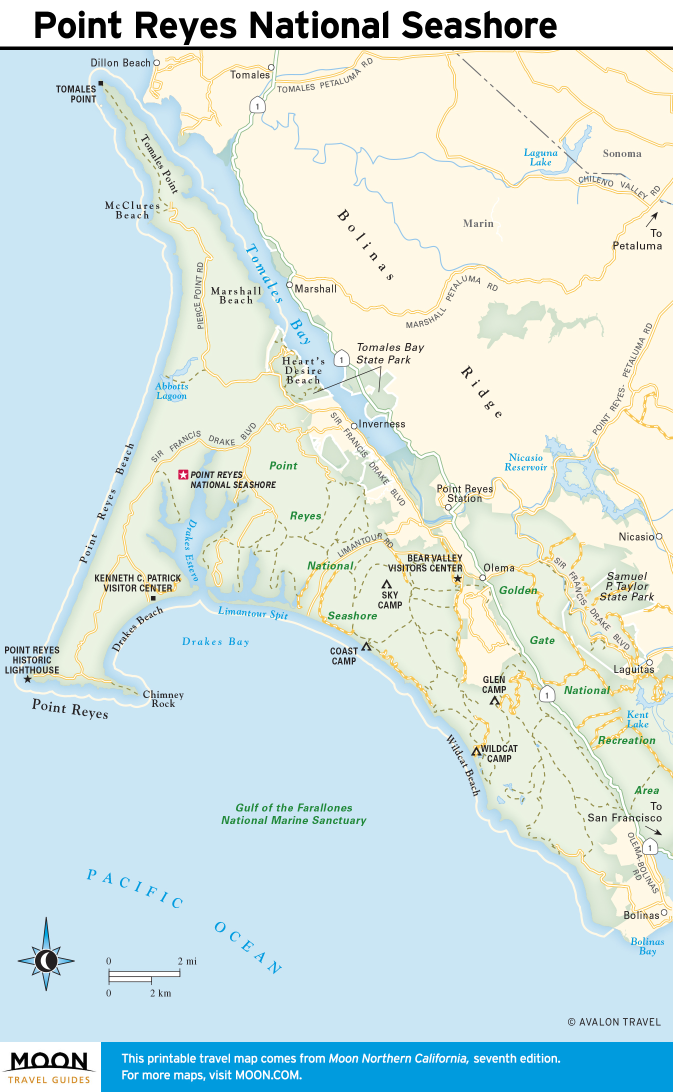
Northwest from town along Sir Francis Drake Boulevard, the 70,000-plus-acre Point Reyes National Seashore offers an entire guidebook’s worth of hiking and cycling trails, broad beaches, dense forests, and more; stop at the Bear Valley Visitor Center (415/464-5100, daily, free) for more information. The photogenic lighthouse at the tip of Point Reyes gives great views over the coast, and in winter and spring (Dec.-June) the steep headland makes an ideal spot for watching migrating gray whales.
Eight miles from the visitors center, the HI Point Reyes Hostel (1390 Limantour Spit Rd., 415/663-8811) has dorm beds in an old farmhouse on the road to Drake’s Bay.
Dozens of delightful inns and restaurants operate in and around Point Reyes, but because they’re a mere 35 miles from San Francisco, they’re often booked solid weeks in advance. Everything from treetop rooms to waterfront cabins can be found through the local chamber of commerce (415/663-9232).
Travel Map of Point Reyes
Bolinas and Stinson Beach
Sitting at the southern end of the Point Reyes peninsula, Bolinas is a small town with a well-earned reputation for discouraging tourists. The signs leading you here from Hwy-1 are regularly torn down by locals bent on keeping the place to themselves. It’s blessed with one of the coast’s best tide-pool areas in Duxbury Reef, which curves around the western edge of Bolinas. The town itself is little more than a general store, a bakery, some cafés, and a bar. The 1850s Smiley’s Saloon & Hotel (41 Wharf Rd., 415/868-1311) offers good food, cold beer, live music, and six upstairs rooms.
In contrast, the broad strands of Stinson Beach, four miles south of Bolinas along Hwy-1, are the Bay Area’s most popular summertime suntanning spots. A grocery store and deli, the Live Water Surf Shop (which rents boards and the essential wetsuits), and a couple of outdoor bar-and-grills along Hwy-1 form a short parade at the entrance to the beach. The best place to eat hereabouts is the Parkside Café (43 Arenal Ave., 415/868-1272). If you want to stay overnight, try the pleasant Sandpiper Lodging (415/868-1632, $145 and up), just west of Hwy-1.
If you have the chance to plan ahead, try to book a night at the Steep Ravine Cabins (800/444-7275, $100), just over a mile south of Stinson Beach on the ocean side of Hwy-1. Now part of Mt. Tamalpais State Park, these nine rustic redwood cabins are very basic roof-over-the-head accommodations (bring sleeping bags and food; water faucets are just outside the door) in an absolutely beautiful coastal chasm. These very popular cabins (originally owned by Bay Area bigwigs like Dorothea Lange) sleep up to five people.
Northern California Travel Map
Related Travel Guides