San Francisco
Across San Francisco
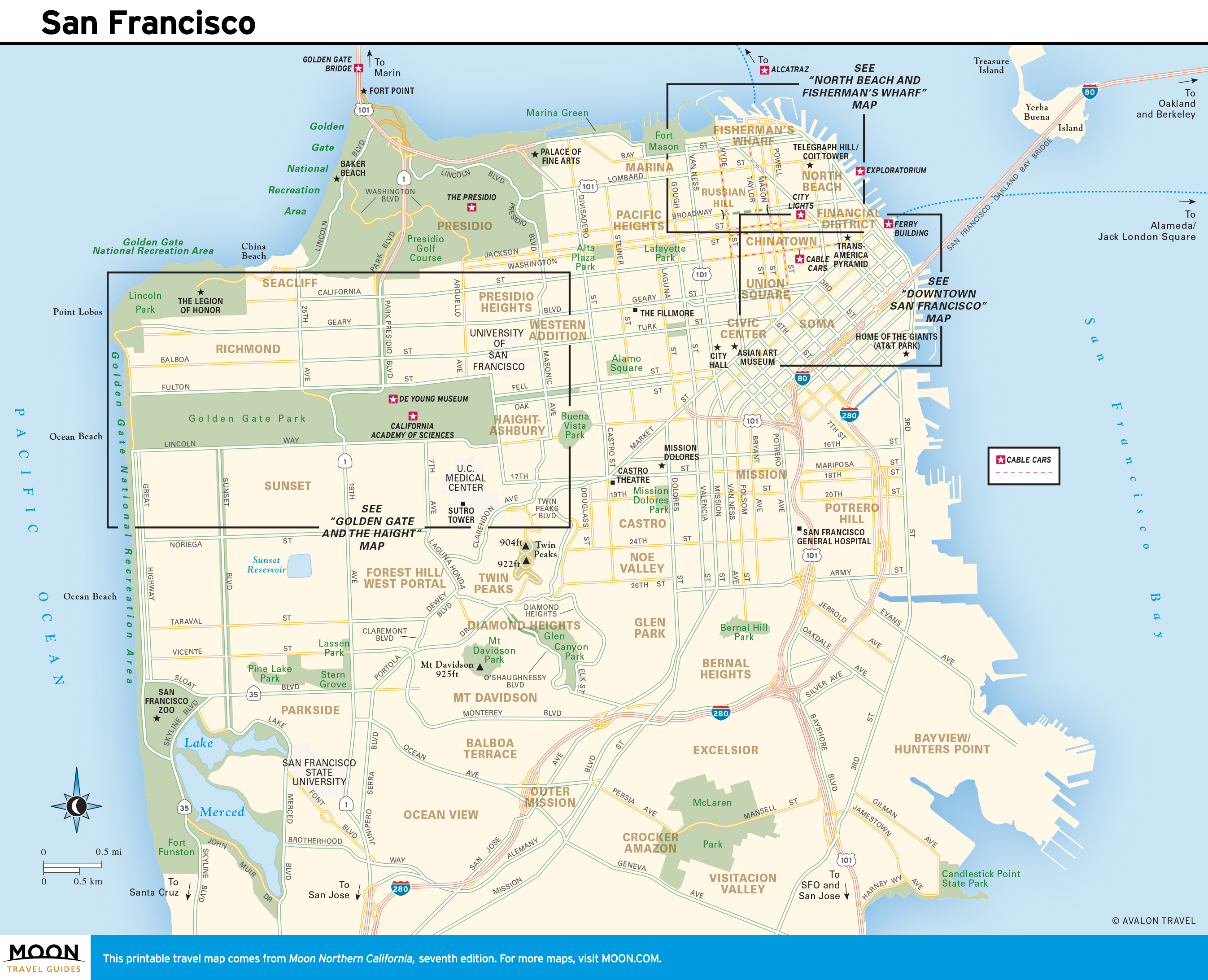
From the north, Hwy-1 enters San Francisco across the glorious Golden Gate Bridge, where parking areas at both ends let you ditch the car and walk across the elegant 1.7-mile-long span. South from the bridge, Hwy-1 follows 19th Avenue across Golden Gate Park, then runs due south through the outer reaches of San Francisco, finally reaching the coast again at the often-foggy town of Pacifica. The most scenic alternative is the 49-Mile Scenic Drive, the best part of which heads west from the bridge through the Presidio, along Lincoln Boulevard and Camino del Mar, following the rugged coastline to Lands End, where you can hike around and explore the remains of Sutro Baths, eat a burger or grilled cheese at Louis’ (415/387-6330), a historic diner with amazing views, or dine at the wonderful (and not all that expensive) Cliff House (415/386-3330).
From Lands End, this scenic route runs south along the oceanfront Great Highway, which eventually links back up with Hwy-1 near the small but enjoyable San Francisco Zoo (415/753-7080, daily, $22 adults).
Since driving and parking in San Francisco can be frustrating and expensive (Steve McQueen could never make Bullitt in today’s traffic), consider parking out here in the burbs and taking public transportation into the center of town. The N Judah Muni trolley line runs between downtown and the coast just south of Golden Gate Park, via the Sunset District neighborhood, where parking is comparatively plentiful.
Exploring San Francisco
San Francisco is easily the most enjoyable city in the United States. Its undulating topography turns every other corner into a scenic vista, while its many distinctive neighborhoods are perfect for aimless wandering. Museums document everything from gold rush history to cutting-edge modern art, while stellar restaurants offer the chance to sample gourmet food from around the world–all in an easily manageable, densely compact small city.
If there’s one place in the city you should stop to get your bearings, it’s the massive 1861 Fort Point, which stands directly beneath the Golden Gate Bridge. You can wander at will through the honeycomb of corridors, staircases, and gun ports, watch the fearless surfers and windsurfers offshore, and take in a panoramic view of the City by the Bay. From here you can walk up to and across the Golden Gate Bridge, or head west to Land’s End or back into town via a popular bay-front walking and cycling trail. Another great place to get a feel for San Francisco is Golden Gate Park, which stretches inland from the western edge of the city, including more than 1,000 acres (405 ha) of gardens, the Conservatory of Flowers, and two landmark museums, the copper-clad de Young Museum, and the natural history, aquarium, and planetarium of the grass-roofed California Academy of Sciences.
If there’s one other place that ought to be on your S.F. itinerary, it’s Alcatraz. Aptly known as The Rock, this was America’s most notorious prison from 1934 until 1963. Now preserved as a historical park, the island is worth a visit as much for the views of San Francisco as for its grim past. To reach Alcatraz, take one of the ferries that leave throughout the day from Pier 33.
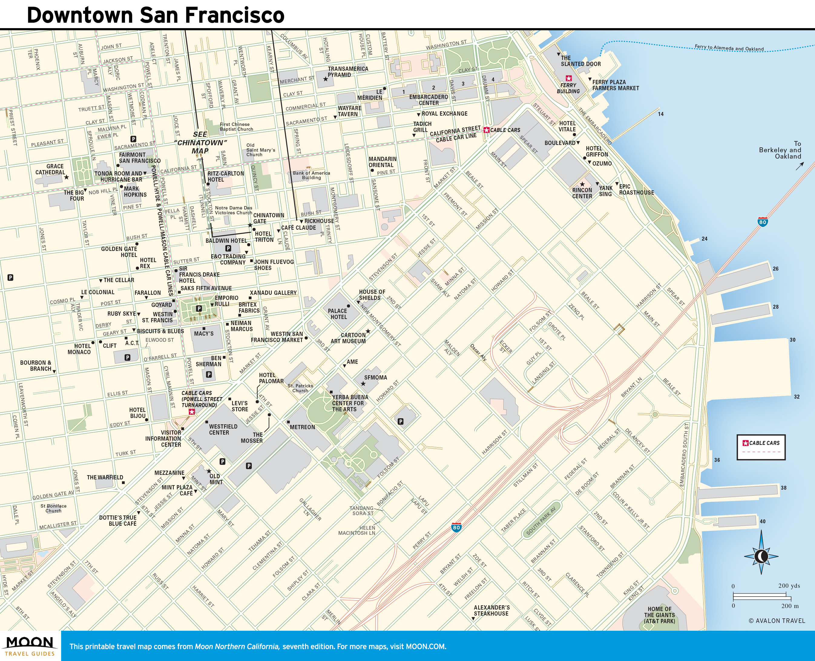
The San Francisco Giants (877/473-4849, tickets $25 and up) play at retro-modern Oracle Park, along the bay in downtown’s South of Market district.
San Francisco Practicalities
San Francisco is one of the few cities on the West Coast where you don’t need a car, since distances are short and public transportation is quite extensive; the grid street plan makes it easy to find your way around. San Francisco’s Municipal Railway (Muni; 415/673-6864 or 311) network of public transit buses, trams, and cable cars will take you all over the city.
The only problem for visitors in San Francisco is deciding where to eat–there are so many great places that choosing among them can be a painful process. For breakfast, Sears Fine Foods (439 Powell St., 415/986-0700) on Union Square is a local institution. Two more SF culinary landmarks are the Swan Oyster Depot (1517 Polk St., 415/673-1101 or 415/673-2757, Mon.-Sat. 10:30am-5:30pm), a half block north of the California Street cable car, a simple oyster bar serving the city’s freshest shellfish and coldest Anchor Steam beer; and Sam’s Grill & Seafood Restaurant (374 Bush St., 415/421-0594), downtown, with incredible grilled meat and fish dishes, melt-in-your-mouth shoestring fries, and ancient-looking 1930s wooden booths that seem like set pieces from a Sam Spade mystery.
Given San Francisco’s worldwide popularity, it’s no surprise that room rates run pretty high–expect to pay $250 a night or more, plus parking and taxes. The best budget options are three HI hostels, one on the bay at Fort Mason (415/771-7277), another downtown (312 Mason St., 415/788-5604), and a third near Civic Center (685 Ellis St., 415/474-5721). Each one costs about $40 and starts at $110 for a private room. In between there are some nice motels on the outskirts of downtown, like the nouveau retro Hotel del Sol (3100 Webster St., 415/921-5520, $175 and up), in the Marina District.
San Francisco Travel Maps
Related Travel Guides