Madras to Prineville
Madras
After crossing the Deschutes River from the Warm Springs reservation, US-26 climbs up a deep canyon, then plateaus at Madras (pop. 6,944), birthplace of the late actor River Phoenix and of Boston Red Sox baseball hero Jacoby Ellsbury. By strange coincidence, the town is named for a metropolis in Eastern India (the original Madras is now called Chennai and has a population of seven million). In the 1980s thousands of orange- and red-clad followers of Indian guru Bhagwan Shree Rajneesh settled near and effectively took over this small Oregon town, but things here have been back to normal for a long while.
There’s not a great deal to see or do in Madras, which stands at the junction of US-26 and busy US-97, but there are stores and gas stations. The best food is at the Black Bear Diner (237 SW 4th St., 541/475-6632), a block west of US-26.
One of eastern Oregon’s landmarks, and a celebrated challenge to rock climbers, Smith Rock State Park (541/548-7501 or 800/551-6949, $5) is 24 mi (39 km) south of Madras along US-97.
Prineville
South of Madras, US-26 veers farther away from the Cascades, crossing the Crooked River National Grasslands, which mark the geographical center of Oregon. Strolling the streets of Prineville (pop. 10,329), you’ll notice plenty of cowboy hats (and “gimme” caps, emblazoned with the logo of the wearer’s favorite fertilizer or tractor company) atop the heads of dusty citizens piloting dusty pickup trucks. It’s been a ripsnorter of a town since Barney Prine built his blacksmith shop and saloon here in 1868 following the discovery of gold in nearby hills. These days, the people of Prineville are still ranchers, loggers, and miners, plus perhaps 300 employees of social media company Facebook, which, in 2011, established the first of now seven data centers covering 3.2 million sq ft (297,300 sq m). Tourism, too, is slowly but surely making its mark as an economic force.
You can learn more about the region’s history at the A. R. Bowman Museum (246 N. Main St., 541/447-3715, 10am-5pm Tues.-Fri. and 11am-4pm Sat. winter, 10am-5pm Mon.-Fri. and 11am-4pm Sat.-Sun. summer, free), two blocks west of the landmark Crook County Circuit Courthouse (300 NE 3rd St.). Two floors of exhibits include a campfire setup, a moonshine still, and a country store with a pound of Bull Durham tobacco. A tastier way to get a handle on life here in the middle of Oregon is to chomp down on a juicy steak at Barney Prine’s Steakhouse and Saloon (389 NW 4th St., 541/447-3333), known for its generous and eclectic menu. Lodging choices include the City Center Motel (509 NE 3rd St., 541/447-5522, $74 and up), in the middle of the city.
The drive along US-26 east of Prineville takes you up into the Ochocos, a low-slung gem of a mountain range once the heartland of the Paiute people. Seven mi (11.3 km) from Prineville, US-26 skirts Ochoco Lake, a popular recreational reservoir with fishing, boating, hiking, camping, and a picnic bench or two for travelers—but not a lot of shade. The rest of the Ochoco Range, which reaches heights of nearly 7,000 ft (2,134 m), holds acres and acres of lovely meadows, clear streams, pristine pine forests, and views of the jagged Cascade Range, rising on the western horizon.
Related Travel Guides

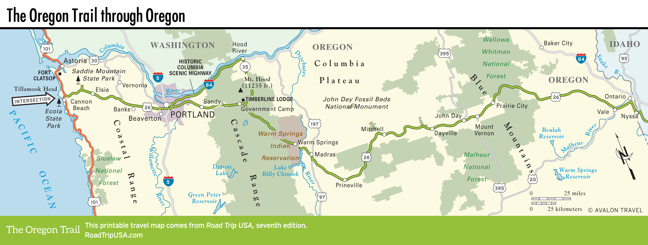
Map of the Oregon Trail through Oregon