John Day Fossil Beds National Monument
Mitchell
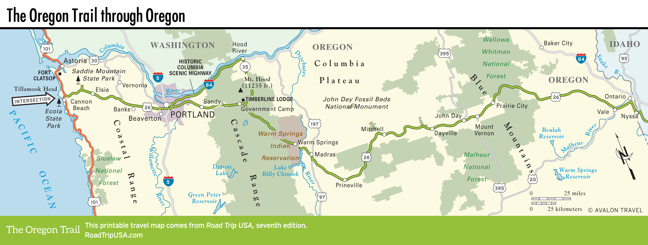
The only concentration of human habitation near the John Day Fossil Beds National Monument is Mitchell (pop. 125), a semi-ghost town 45 mi (72 km) or so east of Prineville and 2 mi (3.2 km) east of the turnoff for the Painted Hills section of the fossil beds. The main “town” of Mitchell lines up along the three-block stretch of old road signed as the Business Loop, just south of US-26, where Main Street holds the old-fashioned general store Wheeler County Trading Co., capturing the flavor of the 1870s, and the pleasant Little Pine Café and Lodge (100 E. Main St., 541/462-3532), which offers great berry pies.
Mitchell also holds one of the more atmospheric old places to stay in this part of eastern Oregon: The Oregon Hotel (104 E. Main St., 541/462-3027, $50-110) has genuinely friendly owners and a comfy front porch overlooking the lazy old-road loop.
John Day Fossil Beds National Monument
East of the Ochocos, midway across Oregon, the John Day Fossil Beds National Monument documents many millions of years of prehistoric life, from just after the demise of the dinosaurs to delicate aquatic plants. In the 1860s, frontier preacher and amateur geologist Thomas Condon was the first to recognize the importance of the beds, which contain one of the world’s richest and most diverse concentrations of mammalian and reptilian fossils, including saber-toothed cats. Offering a visually attractive and easily accessible record of life on earth, spanning the past 6 million to 54 million years (out of some 4.5 billion that our planet has existed), the monument is made up of three distinct units, totaling more than 14,000 ac (5,666 ha). Needless to say, fossil collecting is strictly prohibited in the park.
The eerie, empty moonscape can be easily toured from US-26. Start in the west with the Painted Hills Unit, just west of Mitchell, then 6 mi (9.6 km) north of US-26, where trails and overlooks offer views of striated hills and bluffs formed by fallen ash and brilliantly colored in bands of red, pink, black, and bronze. A life-size Georgia O’Keeffe landscape, Painted Hills is a popular spot with photographers and painters, especially the short Painted Cove trail, which winds through the most intense colors.
About 35 mi (56 km) east of Mitchell, 5 mi (8 km) west of Dayville along US-26, then 2 mi (3.2 km) north on Hwy-19, the Sheep Rock Unit (541/987-2333) is the best place to see fossils up close. The monument headquarters and main paleontology museum are also here, housed inside an attractive modern building on the grounds of the historic Cant Ranch. East of the turnoff to the Sheep Rock fossil beds, US-26 runs right along the John Day River through the 1,300-ft-deep (396-m) basalt canyon of Picture Gorge, so named because of the abundance of Native American pictographs.
A more distant section of the John Day Fossil Beds is the Clarno Unit, along the John Day River some 60 mi (97 km) northwest of Painted Hills, near the aptly named town of Fossil, home of the fascinating Oregon Paleo Lands Institute (333 W. 4th St., 541/763-4480). This area includes the park’s most ancient rocks—that formed 40 million to 54 million years ago—while the oldest rocks in Oregon, dating back 225 million years, can be seen atop volcanic Canyon Mountain, south of John Day village.
Related Travel Guides

Map of the Oregon Trail through Oregon