Camp 18 to Vernonia
Camp 18
Continuing east on US-26, 60 mi (97 km) from Portland, about 18 mi (29 km) from the coast highway and a mile (1.6 km) west of the hamlet of Elsie, the remarkable Camp 18 Logging Museum and Restaurant (503/755-1818 or 800/874-1810, daily) draws travelers for a variety of reasons. Some people come for the absolutely massive portions of good food, from the gigantic fresh-baked cinnamon rolls and quart jugs of coffee at breakfast to the steaks, chicken, and seafood served up at lunch and dinner. Others are drawn by the playful Paul Bunyan-esque scale of the place: The front door handle is a hefty old ax, the spacious dining room roof is held up by a single massive Douglas fir log—85 ft (26 m) long, 8 ft (2.4 m) thick, and weighing 50,000 pounds (22,680 kg)—and many of the tables are made from foot-thick planks of planed and polished wood.
The whole room is packed with an amazing collection of old logging gear, but best of all is the setting, overlooking a babbling brook, with dozens of bird-feeders attracting flocks of finches and other colorful songbirds. Outside, an extensive museum in the parking lot lets visitors examine more old logging equipment to get a feel for a bygone era of misery whips, 20-ft (6-m) handsaws, and steam donkeys. (Surprise, surprise: There’s also a good gift shop.)
Banks-Vernonia Linear State Trail
Midway between the coast and Portland, US-26 reaches the 1,640-ft (500-m) crest of Sunset Summit, then winds east through the verdant delights of the leeward Coast Range, zipping through tunnels and sliding down slopes to the farm country of northwest Willamette Valley. Banks-Vernonia State Trail (503/324-0606 or 800/551-6949, free), 35 mi (56 km) or so from downtown Portland, is a 21-mi (34-km) stretch of abandoned railroad that runs north from US-26 between the town of Banks and the tucked-away timber town of Vernonia. Six well-marked trailheads along Hwy-47 provide access to the fairly level gravel trail, Oregon’s first rail-to-trail park. The park is especially lovely, and popular, during October’s “fall color” season, when the many ash and maple trees turn gold and red, respectively, while the birds sing and the streams gurgle.
Vernonia
The town of Vernonia (pop. 2,274) has recently played another role in Pacific Northwest tourism, standing in for Forks, Washington, in the movie versions of the teenage vampire saga Twilight. (A paper mill credit union office at the center of Vernonia stood in for the film’s Forks Police Station, for example.) Vernonia is cute, having recovered from a bad flood some years ago, and is a nice destination whether or not you’ve seen the movies. After a day of hiking or cycling the Linear Trail, recharge your carb deficits with a Greek gyro and a hoppy pint of homebrew at the Blue House Café (919 Bridge St., 503/429-4350), in the center of town.
Related Travel Guides

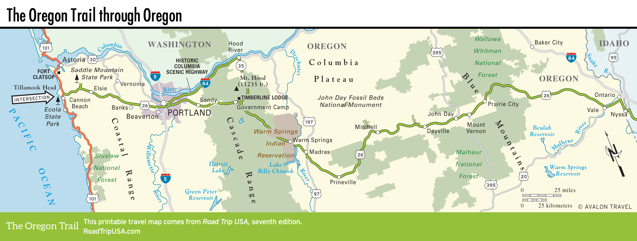
Map of the Oregon Trail through Oregon