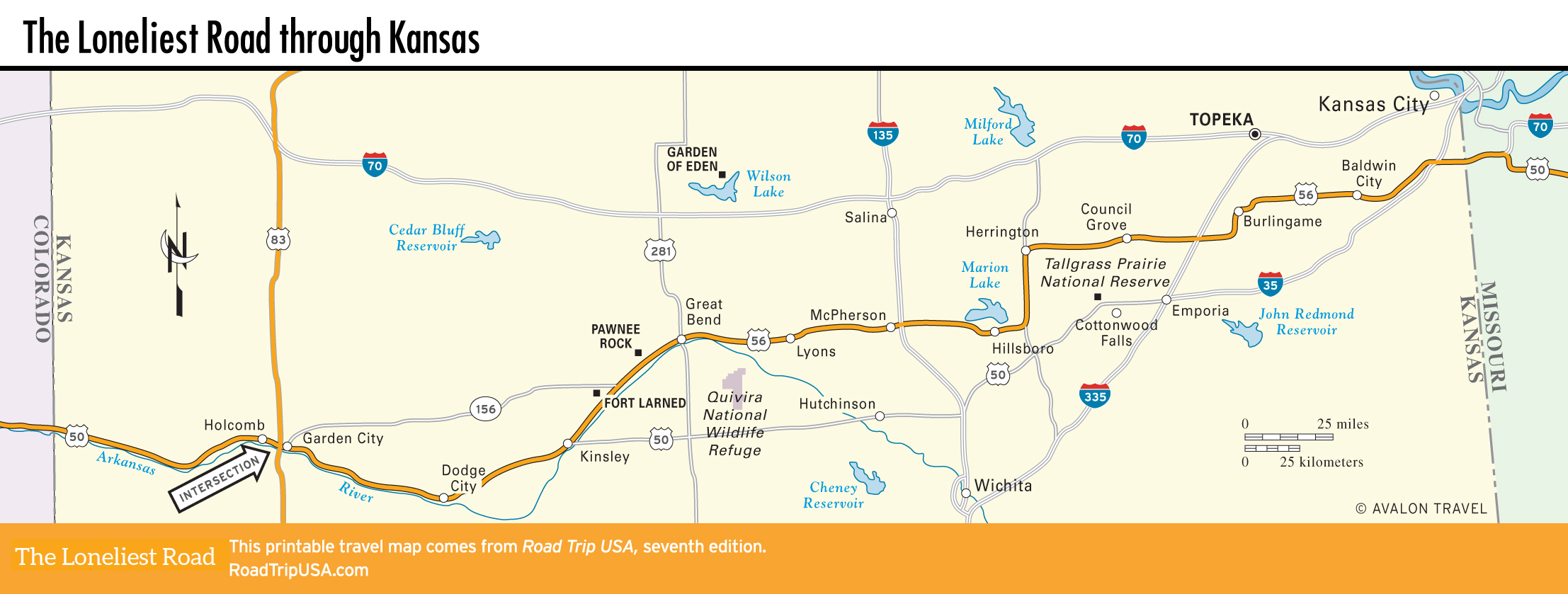
Holcomb to Dodge City
Holcomb
Apart from numerous feedlots fattening cattle for slaughter and a few wheat, corn, and beet farms fed by water diverted from the Arkansas River, there’s not much to see in the 120 miles of barren plains that stretch east from the Colorado border. On the western outskirts of Garden City, the region’s biggest town, US-50 runs through the meat-packing town of Holcomb, notorious as the site of the In Cold Blood murders documented by Truman Capote and in a pair of mid-2000s Hollywood bio-pics (Capote and Infamous). In 1959, Perry Smith and Richard Hickock ruthlessly killed all four members of the Clutter family during a robbery attempt. Both killers were eventually captured, convicted, and executed.
Santa Fe Trail Tracks
One of the best-preserved sections of Santa Fe Trail wagon tracks is 10 mi (16.1 km) west of Dodge City along this stretch of US-50. Marked by a large sign, just west of the Howell grain elevator, these wheel tracks, or ruts, lie in a rolling field 100 yards (91 m) north of the parking area and are basically a broad depression in the soil, approximately 800 yards (731 m) wide and 2 mi (3.2 km) long.
Farther west, at Cimarron, 34 mi (55 mi) east of Garden City and 18 mi (29 km) west of Dodge City, the main track of the Santa Fe Trail crossed the Arkansas River and headed southwest across the waterless plain of the Jornada del Muerto on what was known as the Cimarron Cutoff. This desolate region is also where, in 1831 during the earliest days of the trail, legendary mountain man Jedediah Strong Smith was killed by a band of Comanche warriors.
Dodge City
One of the most notorious places on the Wild West frontier, Dodge City (pop. 27,329) can be something of a disappointment if you come here looking for a rip-roaring frontier town. In its heyday, which lasted roughly from 1872, when the railroad arrived, to 1884, when the cattle drives were effectively banned, Dodge City was the undisputed capital of the buffalo-hunting, cattle-driving Wild West, with as many as 100 million bison hides and seven million head of cattle shipped out from here in that decade alone. At the same time, Dodge City was known as “Hell on the Plains,” famous for its gunfights and general lawlessness, despite marshals like Bat Masterson and Wyatt Earp keeping order and planting bad guys in the Boot Hill cemetery above town.
However, almost nothing in Dodge City survives from that era. Boot Hill, for example, was bought by the city and is now the site of a small office building. (A statue of a cowboy, erected in 1927, says somewhat mournfully: “On the ashes of my campfire this city is built.”) Most of what you see in Dodge City dates from the 1920s at the earliest, and Dodge City is by and large a busy farming and cattle-ranching community, with extensive stockyards surrounding the small downtown area. Because of the low-profit economics of the beef industry, most of the 4,000 to 5,000 people who work in the feedlots and slaughterhouses today are immigrant workers from Mexico—which explains the predominance of Mexican cafés and grocery stores around town.
For travelers, there’s little here apart from one of the Midwest’s more heavily hyped tourist attractions, the fake but fun Boot Hill Museum (620/227-8188, daily, $12) and its recreated Front Street, where actors stage gunfights and “medicine shows” throughout the day. There’s also an evening burlesque show, featuring Miss Kitty and her Can-Can Girls; a reconstructed sod house; the old (circa-1865) jail; and a one-room schoolhouse. A historic Santa Fe locomotive completes the Boot Hill collection; not surprisingly, Boot Hill is hard to miss, well marked on the west side of town, just north of the railroad tracks along Wyatt Earp Boulevard (US-50/56), the main route through town.
Related Travel Guides