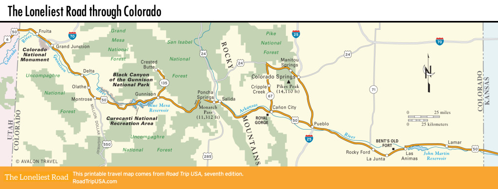
Black Canyon of the Gunnison National Park
Black Canyon of the Gunnison National Park
Some of the hardest and oldest rocks on earth form the sheer walls of the more than 2,000-ft-deep (610-m) Black Canyon of the Gunnison, the deepest and most impressive gorge in the state. The river cutting through the canyon falls faster than any other in North America—dropping 2,150 ft (655 m) in under 50 mi (81 km)—and the canyon bottom is so rugged that there are no trails along it. Unless you’re a serious mountaineer, you’ll have to content yourself with looking down into it from the rim, which is accessible on the north side via Hwy-92 and from US-50 on the south via Hwy-347. The visitors center (970/249-1914 or 970/641-2337) on the south rim provides details on hiking trails and camping and can tell you more than you ever wanted to know about the canyon’s unique geology: For instance, unlike the Grand Canyon, with its layers of exposed rock, the Black Canyon is basically one solid hunk of stone, a half-mile-thick chunk of two-billion-year-old Precambrian gneiss (pronounced “nice”).
Upstream from the Black Canyon, US-50 parallels the Gunnison River, renowned for its excellent trout and landlocked salmon fishing, though sadly the once-raging waters have been backed up behind dams to form a series of reservoirs, jointly managed as the Curecanti National Recreation Area.
Gunnison and Crested Butte
A crossroads cattle town with a rapidly growing recreational aspect and the only commercial airport for miles, Gunnison (pop. 6,594; elev. 7,703 ft/2,349 m) is made livelier than many Colorado towns by the presence of Western State Colorado University, whose ski-bumming students are responsible for the town’s many bike shops and Internet cafés, not to mention the huge “W” that marks a mountainside south of town. Stop by the lively W Café (114 N. Main St., 970/641-1744), marked by a nifty neon sign, for a bite to eat. Motels line up along US-50, which runs through the redbrick heart of the old downtown, making Gunnison a handy base for exploring the region.
If you’re taken with the scenery around Gunnison and want to see more, head north along Hwy-135 and the Gunnison River to the area’s skiing and mountain biking center, Crested Butte (pop. 1,681), about 25 mi (40 km) away. As in Telluride and Aspen, this 100-year-old gold-mining camp won a second lease on life thanks to tourism, though compared to other Colorado places, Crested Butte is low-key and somewhat off the beaten path. Skiers in search of solitude flock here in winter to cruise the 1,500-plus ac (607 ha) of Mt. Crested Butte, while in summer Crested Butte is a mountain-bike mecca, home to miles upon miles of mining roads and single-track trails winding through the mountains. (The ski lifts convert to bike lifts, to save you suffering on the climb back uphill.)
Relax while you recharge your batteries with a burger and a beer or two at the Wooden Nickel (222 Elk Ave., 970/349-6350).
Three blocks north of Elk Avenue, the Crested Butte Hostel (615 Teocalli Ave., 888/412-7087, private room with shared bath $100 and up). There are also hotels and condos available through the ski resort (970/349-2262 or 877/547-5143).
Monarch Pass
East of Gunnison, the landscape changes swiftly as US-50, along with a few daring cyclists, climbs steeply through a gorgeous alpine landscape of meadows and cattle ranches toward 11,312-ft (3,448-m) Monarch Pass. The pass marks the highest point on US-50 and straddles the Continental Divide: The 30 ft (9 m) of annual snowfall on the east side of the pass end up in the Atlantic, while (in theory, at least) moisture falling farther west makes its way to the Pacific. There’s a ski and snowboarding area here in winter, and in summer you can ride a tram or hike to a nearby summit for a 360-degree view over the Rocky and Sangre de Cristo Mountains.
Related Travel Guides