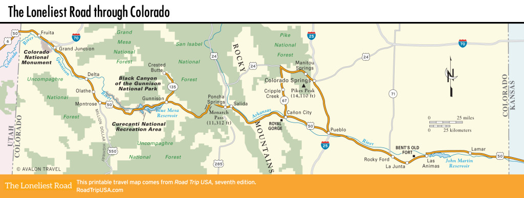
La Junta to Lamar
La Junta: Mountain Branch of the Santa Fe Trail
For eastbound travelers, La Junta (pop. 6,998), a busy railroad town on the banks of the Arkansas River, is where we begin tracing the historic Santa Fe Trail. The name La Junta, which means “the junction,” is apt, since the town has long been a key crossroads, first on the Santa Fe Trail and now as the main Amtrak stop south of Denver. The town’s excellent Koshare Indian Museum (115 W. 18th St., 719/384-4411, daily summer, Wed.-Sun. winter, $5) is housed in a giant kiva-shaped structure on the campus of Otero Junior College, on the south side of town. It’s a local tradition for Boy Scouts to don Native American regalia and perform interpretive dances on-site (Sat. June-July, $10).
La Junta also offers gas stations, a good range of places to eat (Mexican restaurants are a particular strength), a two-screen movie theater, and an ancient-looking barbershop. Sleep cheap at the clean and friendly Midtown Motel (215 E. 3rd St., 719/384-7741, $50 and up).
La Junta also marks the spot where the Mountain Branch of the Santa Fe Trail finally cuts away to the south, following what’s now US-350 through the Comanche National Grassland and continuing over Raton Pass into New Mexico and on to Santa Fe. Eastbound travelers are in luck, as we follow this historic route all the way to the other side of Kansas City.
Detour: Bent’s Old Fort
From La Junta, an interesting quick detour off US-50, Hwy-194 runs along the north bank of the Arkansas River to one of Colorado’s most evocative historic sites, Bent’s Old Fort (719/383-5010, daily, $3). It lies 8 mi (12.8 km) east of La Junta, or 15 mi (24 km) west of Las Animas. From 1833, when it was built by the fur traders William and Charles Bent, until 1848, when war with Mexico and increasing unrest among the local Arapahoe, Apache, and Cheyenne peoples put an end to their business, Bent’s Fort was the Southwest’s most important outpost of American civilization, and a stopping place for travelers, trappers, and explorers, including John C. Fremont, Francis Parkman, and just about every other Wild West luminary.
Though it was abandoned and left to decay for over 100 years, the large adobe fort was authentically rebuilt by the National Park Service in 1976 and now stands as a palpable reminder of the early years of the frontier era. Thick adobe walls, 15 ft (4.5 m) tall with circular bastions at the corners, protect the roughly square compound. Rangers, dressed in period clothing during special events, work as wheelwrights, coopers, and carpenters, or process the many buffalo robes and beaver pelts piled up in storerooms.
Las Animas
The farming community of Las Animas (pop. 2,190) takes its name from the Arkansas River tributary originally known as Río de las Animas Perdidas en Purgatorio (River of Lost Souls). Las Animas is also the place where, on November 15, 1806, Lieutenant Zebulon Pike first laid eyes on the Rocky Mountain peak that now bears his name—Pike’s Peak, 120 mi (193 km) to the northwest.
Beyond Las Animas, US-50 continues its gradual descent across the Rocky Mountains foothills. The area was first known as Big Timbers for the tall cottonwoods that grew here along the Arkansas River, though most of these trees were cut down soon after the arrival of white settlers. In the 1840s and 1850s, local Cheyenne, Arapahoe, Kiowa, and Apache peoples bartered bison hides at William Bent’s trading post, and Wild West explorer Kit Carson died here on May 23, 1868, in his family home at what was then the U.S. Army’s Fort Lyon, south of present-day US-50. Carson’s remains were later moved to Taos, New Mexico, and his lands were flooded after the Arkansas River was dammed to form the large John Martin Reservoir, which stretches most of the way downstream to Lamar.
Lamar
Following the Arkansas River downstream toward the Kansas border, US-50 runs along what was known as the Mountain Branch of the Santa Fe Trail, a longer but safer alternative to the main route along the Cimarron Cutoff. Massive truck stops and acres and acres of irrigated farmlands, feedlots, and cattle ranches greet you in Lamar (pop. 7,656). It’s worth a stop, if only to admire the “World’s Oldest Gas Station” (501 N. Main St.). Built out of blocks of 175-million-year-old petrified wood, the structure opened as a gas station in 1932. Although the building still attracts tourists, it is now used for storage.
At the heart of town, next to the Old Depot, a stately Madonna of the Trail stands as a reminder of the indefatigable spirit of the pioneers. Standing nearly 20 ft (6 m) tall atop an engraved plinth, this statue is one of 12 identical memorials erected in the 1920s by the Daughters of the American Revolution (DAR). From Bethesda, Maryland, to Upland, California, the memorials were placed along the original National Old Trails Highway, which followed the National Road (US-40) and later Route 66 on the westward path of Manifest Destiny.
North of Lamar, then east of US-287, the Sand Creek Massacre National Historic Site (719/438-5916, Thurs.-Mon. Apr.-Oct., Mon.-Fri. Nov.-Feb., free) preserves and interprets the place where, in November 1864, volunteer U.S. soldiers opened fire on a camp of Cheyenne and Arapahoe people, killing more than 100 unarmed women and children. An investigation by the U.S. Congress vilified the cowardly and racist murders, saying that while “wearing the uniform of the United States, which should be the emblem of justice and humanity” the soldiers “deliberately planned and executed a foul and dastardly massacre.” There’s not a lot to see or do, but standing on the site is at once profound, symbolic, and deeply disturbing.
Related Travel Guides