The Yellow Banks to Burlington
The Yellow Banks of Illinois
Zigzagging for nearly 100 mi (151 km) south of the Quad Cities, the GRR picks its way along a series of back roads through Illinois floodplain and prairie, where frequent small farming towns serve as reminders of the need for frequent stops by early stages, steamboats, and railroads. Most of the towns seem not to have changed much since the last steamboat or train whistle blew, although now there’s neon in the bars, vinyl and aluminum siding on the houses, and farmers with high-powered four-by-fours on the roads.
Nearly 45 mi (72 km) south of the Quad Cities beltway, the GRR passes tiny New Boston, where the Mississippi is fed by the mouth of the Iowa River. The town is a historical footnote these days, having been surveyed by the young Abraham Lincoln after his stint in the Army—a tour of duty during which his only combat was against mosquitoes, he later recalled.
Along the river farther south, near Keithsburg, a sign welcomes travelers to the Yellow Banks, named for the deep layer of sand exposed in the river valley in this region. Because of this deposit, visitors can find sandburs and even cactus in the Big River State Forest south of town. Keithsburg used to be one of a number of button manufacturing centers located along the middle Mississippi: Freshwater clams were dredged from the river bottom and their shells were used for making pearl buttons.
Burlington, Iowa
Across the Mississippi River via an austere modern suspension bridge, Burlington was the frontier capital of Iowa, founded in 1833 and home to many Victorian homes and commercial buildings. In 1887 Burlington gave birth to the great American nature writer Aldo Leopold, then in 2004 the city was awarded “Great American Main Street” status from the National Trust for Historic Preservation. Now it has a fun Class A baseball team (the Bees, a Los Angeles Angels farm team), a casino, a nice bridge over the Mississippi, a great All-Star Maid-Rite Diner (112 W. Division St., 319/758-7648), and some busy downtown rail yards—onetime home base of the Burlington Northern Santa Fe (BNSF) railroad conglomerate.
If you have time to wander away from the river and downtown areas, head up to the 6th Street shopping district on Heritage Hill, following the twists and turns of “Snake Alley,” a section of Washington Street that Ripley’s Believe It or Not once called “Unbelievably Crooked.”
At Niota, the ghost of a town that marks the next crossing south of Burlington, a nifty old 1920s double-decker swing bridge (trains below, cars on top) crosses the Mississippi, landing on the west bank in the historic town of Fort Madison, Iowa.
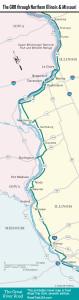
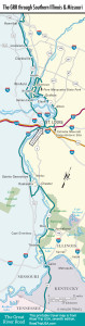
Maps of the Great River Road from Illinois to Missouri
Related Travel Guides