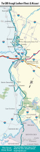
Louisiana and Clarksville
For the first 20-odd mi (32 km) south from Hannibal, the GRR ascends and descends the densely wooded tops of bluffs, pausing at scenic turnouts for views across the Mississippi Valley, here many miles wide. In October, the upland forests are blazing with fall color that compares with any outside New England, and if you roll down the windows or stop to stretch your legs during the summer, listen for the omnipresent buzz of cicadas in the tangled undergrowth.
Another icon of the lower Mississippi, one that has extended its range north, like the cicadas (and the fire ant), is the huge and pungent chemical plant on the south side of the town of Louisiana (pop. 3,253), originally constructed in the 1940s to create synthetic alternatives to fossil fuels. The town itself has one of the Midwest’s most intact Victorian-era streetscapes, full of 125-year-old brick cottages and warehouses, but looks like it has just about lost the battle against extinction.
A short ways farther south, Clarksville (pop. 431) is another GRR town with more of a past than a future, but some optimistic restorers of the riverfront historic block are counting on tourism to improve the town fortunes.
Claiming preeminence as the highest point along this stretch of the Mississippi River, 900-ft (274 m) Pinnacle Peak is also noteworthy for the rusty remains of its old Sky Ride chairlift, which once carried riders over the GRR all the way to the summit. The Sky Ride has been undergoing restoration for about 30 years, without much sign of progress toward reopening. Clarksville also boasts what may be the largest concentration of bald eagles in the lower 48 states; in winter months they feed by the hundreds below Lock and Dam No. 24, on the northern edge of town.
Swinging away from the river south of Clarksville, the GRR reenters the corn belt in great straight stretches of road, rising and falling over rolling prairie still hilly enough that you can play peek-a-boo with approaching traffic over the miles of ups and downs, passing towns that often comprise little more than a few houses around a gas station and a grain elevator on a rarely used railroad siding. The landscape feels far away from urban anything, yet you’re less than a half-hour from downtown St. Louis.
Travel Maps of the Great River Road
Related Travel Guides