Essex to Blackfeet Indian Reservation
Essex: The Izaak Walton Inn
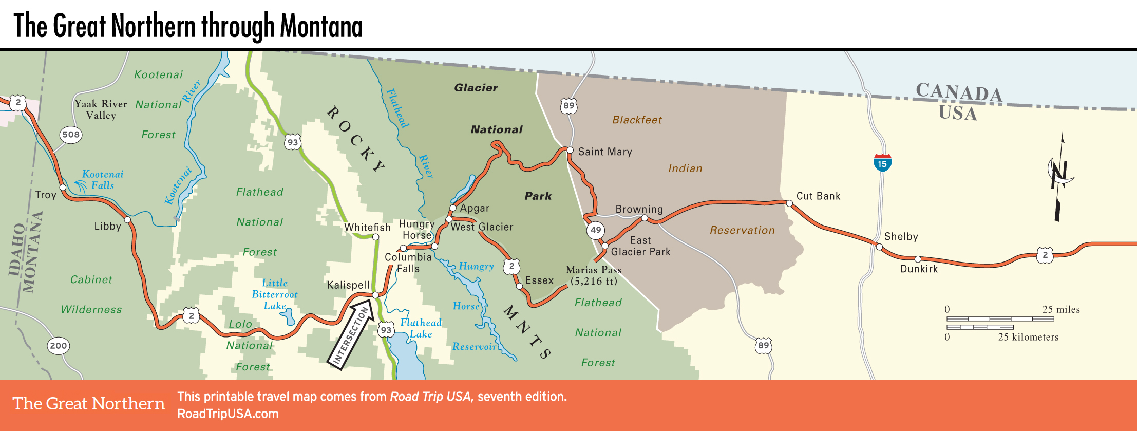
Avoiding the most extreme alpine scenery and the heavy winter snows, US-2 winds around the southern edge of Glacier National Park, climbing over the Continental Divide at 5,213-ft (1,589-m) Marias Pass, the lowest of the Rocky Mountain passes. Though the road and the railroad are kept open year-round, there’s little visible development, and numerous trailheads access the southern reaches of the Glacier National Park backcountry.
One place that’s well worth a stop, or better yet an extended stay, is the Izaak Walton Inn (406/888-5700, $99 and up), midway between East and West Glacier, a half mile south of US-2 in the railroad village of Essex. Especially in winter, when the inn overlooks miles of cross-country ski trails, this is one of the best stops in the state. A humbler version of the grand Glacier Park lodges, the inn was built to house railroad workers (which it still does) and is now a popular year-round alternative to the often overbooked accommodations within the park. The inn also serves good food for breakfast, lunch, and dinner (try the huckleberry desserts).
Another place worth a stop in early summer is the so-called Goat Lick on US-2, near milepost 182 about 4 mi (6.4 km) east of the Essex turnoff, where, in April and May especially, dozens of shaggy white mountain goats congregate around a mineral-rich spring.
East Glacier Park
Situated along US-2 at the southwest edge of the Blackfeet Indian Reservation, the town of East Glacier Park, as the name suggests, is the eastern gateway to Glacier National Park. It has a number of services, including general stores and gas stations, plus Serrano’s (29 Dawson Ave., 406/226-9392), a good Mexican restaurant just south of US-2. North of US-2, on the way to Glacier National Park, there’s more good food available at the Whistle Stop Restaurant (1024 Hwy-49, 406/226-9292).
With the main park entrance over 40 mi (64 km) northeast at St. Mary, East Glacier Park is not an especially convenient base, though it does have one compelling attraction: the Glacier Park Lodge (406/892-2525 or 406/226-5600), the grandest of all the historic park lodges. Built by the Great Northern Railway to attract visitors to the park (and to its trains), the lodge centers on a magnificent lobby built of 40-foot-tall Douglas fir logs—each of which runs floor to ceiling, with the bark still on it. It’s an impressively rustic space, and well worth a look.
St. Mary
Located on the Blackfeet Indian Reservation, 30 mi (48 km) north of US-2 at the east entrance to Glacier National Park, the town of St. Mary makes a great alternative to the in-park lodges. At the east end of the historic Going-to-the-Sun Road, St. Mary has a large Glacier National Park visitors center and the clean, modern St. Mary Lodge & Resort (406/732-4431, $160 and up). Before or after a big day on the trails, you’ll be pleased to find the excellent Park Café and Grocery (3147 US-89, 406/732-9979 or 406/732-9300), which serves mega-breakfasts and yet more great berry pies, a half mile north of the park turnoff. The Park Café is worth planning your day around, as the berry pies are every bit as amazing as Glacier’s Rocky Mountain scenery.
St. Mary makes an especially handy base for visiting the comparatively quiet Many Glacier section of Glacier National Park, and for seeing the sights of adjacent Waterton Lakes National Park, across the border in Canada.
Blackfeet Indian Reservation
The 1.5-million-acre Blackfeet Indian Reservation, stretching north to the Canadian border along the eastern border of Glacier National Park, is a weather-beaten land home to 17,321 members of what was once the most powerful nation on the Northern Plains. The Blackfeet, whose nomadic lives took them all over the plains in pursuit of buffalo, were feared and respected for their fighting and hunting abilities, though contact with white traders brought smallpox, alcoholism, and other diseases that devastated the nation. Their strength in battle won the Blackfeet concessions from the encroaching U.S. government, including a huge swath of land that, in 1855, included everything north of the Yellowstone River between the Dakotas and the Continental Divide. Much of this land, including what’s now the eastern half of Glacier National Park, was later bought back or simply taken away; the Blackfeet Nation now earns most of its income from ranching and oil and natural gas leases.
The Blackfeet Nation’s headquarters and main commercial center is Browning (pop. 1,042), located on US-2 near the eastern entrance to Glacier National Park. There are a couple of places worth stopping, including the Museum of the Plains Indian (Tues.-Sat. summer, Mon.-Fri. fall-spring, $6), near the west end of town at the junction of US-2 and US-89. Operated by the U.S. government’s Bureau of Indian Affairs, the bland building contains a small collection of Plains Indian arts and crafts, mostly blankets and jewelry. Browning, which comes alive during the annual North American Indian Days Powwow in early July, also has a couple of cafés, a small casino, and a large concrete tepee.
Related Travel Guides