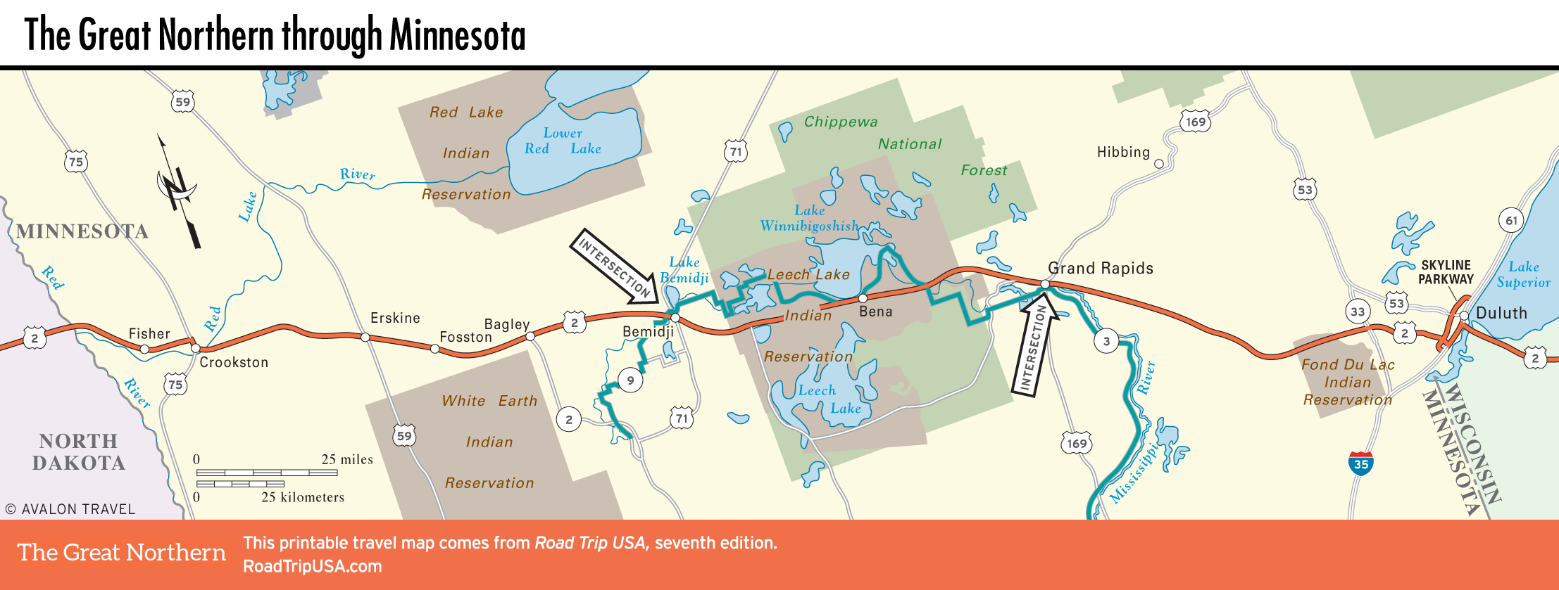
Fisher to Skyline Parkway
Fisher
The first town east of the North Dakota state line, tiny Fisher (pop. 424) doesn’t look like much, but it was once a bustling frontier port, thanks to its location at the navigational headwaters of the Red River of the North. River traffic has all but disappeared, but the local sugar-beet industry pulls in a billion dollars a year, which may explain the town’s prosperous air.
Near Fisher stretches the Malmberg Prairie Preserve, one of the few extant virgin prairies left. Preserved by early settlers and now protected by the Nature Conservancy, these 80 ac (32.4 ha) of wild prairie roses, blue gentians, and bright yellow sunflowers shine in late summer. Once home to herds of bison, the land here has never been plowed, and it looks all the more special, surrounded as it is by acres and acres of industrial-scale agriculture. To reach the preserve from US-2, take US-75 south to Hwy-9, then turn south onto Hwy-56 and drive for 2 mi (3.4 km) until you see the Nature Conservancy sign.
Crookston and Erskine
Crookston (pop. 7,806), 25 mi (40 km) east of the North Dakota border, has a series of bridges over the meandering and tree-lined Red Lake River, which winds along the south side of the compact downtown business district. The small Polk County Historical Museum (Tues.-Sun. Memorial Day-mid-Sept., donation) contains the usual slew of 19th-century stuff alongside the “World’s Largest Ox-Cart” (celebrated in August’s Ox-Cart Days).
In the 100 mi (161 km) east of the North Dakota border, US-2 spreads into a divided four-lane highway, climbing out of the fecund Red River Valley of the North (which is not to be confused with the other Red River Valley, down in Texas) onto the flat glaciated plains, while the roadside colors alternate between the dark reds and greens of sugar beets and the buff and leafy tones of the wheat, soy beans, and potatoes for which the area is known.
Continuing east, US-2 passes occasional isolated pockets of trees, planted as windbreaks amid the furrowed fields. In the tiny village of Erskine (pop. 479), a classic one-horse Midwest town, you’ll find Joe DiMaggio’s Grill and Pizza (218/687-2100), southeast of downtown along the US-2 frontage, which is neither a misprint nor the genuine article. (The owner, Mr. D., used to get oodles of phone calls meant for the legendary Yankee Clipper. Not surprisingly, his place is full of baseball memorabilia.) Erskine also has a swimming beach on Lake Cameron and takes civic pride in being the home of the “World’s Largest Northern Pike” (of whom there’s a 40-ft-long (12.2 m) statue on the pretty downtown lakefront).
Skyline Parkway and Hwy-61
One of the greatest loop trips in the country, bucolic Skyline Parkway winds some 25-mi (40 km) along the bluffs above Duluth (over 30 mi/48 km with side trips). Accessed from West Duluth off I-35, the parkway takes in numerous historical sites, but it’s mostly just jaw-dropping scenery, especially Hawk Ridge, which offers perfect wind conditions for viewing up to 30,000 hawks, eagles, and falcons daily in fall; also along the ridge is a fantastic network of trails, boarding stations, and observation posts. The parkway, which was started in 1889 and completed in 1929, connects at its north end with famed Hwy-61, which, if you’ve got the time to spend, is an even more beautiful jaunt along Lake Superior’s granite cliffs to Grand Portage and Canada, 150 mi (242 km) to the northeast. Along the way are some of the region’s best places to eat: numerous smokehouses touting their smoked fish, plucked from the frigid waters of the great lake.
On Hwy-33, on the edge of the Fond Du Lac Indian Reservation, 9 mi (14.5 km) south of US-2 and 22 mi (35 km) west of Duluth, the town of Cloquet boasts the only gas station ever designed by famed architect Frank Lloyd Wright. Cloquet also has the large Fond-du-Luth Native American-owned casino.
Related Travel Guides