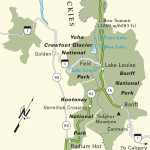
Kootenay National Park
Though Banff and Jasper seem to get all the attention, neighboring Kootenay National Park draws travelers who prefer to experience wilderness without having to wait in line. It was originally known as the “Highway Park,” since the land was deeded to the federal government in exchange for it building the 65-mi (105-km) Banff-Windermere Highway, which now runs through the heart of the park. Completed in 1922, this was the first road over the Canadian Rockies, and it linked the prairies and the west coast of British Columbia for the first time. Fortunately for visitors, Hwy-1, which runs through Yoho to the north, now carries most of the through traffic.
Kootenay National Park spreads for 5 mi (8 km) to either side of the highway. As in all the Canadian Rockies parks, grizzly bears still roam the Kootenay backcountry, and black bears, bighorn sheep, and elk are regularly seen along the roadside. A number of stops along the way offer great short hikes. Two of the most enjoyable, Marble Canyon and Paint Pots, are at the north end of the park, well signed along the north side of the highway. Marble Canyon is an amazing sight (and sound): a narrow slot canyon 100 ft (30 m) deep carved in the shiny white dolomite limestone by the thundering cascade of Tokumm Creek. A half-mile (0.8 km) trail leads back and forth on a series of constructed and natural bridges over the gorge. The Paint Pots, 2 mi (3.2 km) south, are much more sedate, displaying a handful of brightly colored mud puddles dyed varying shades of red and yellow by oxidizing minerals in the natural springs.
You’ll find the park’s only overnight accommodations at Vermilion Crossing at the center of the park, about 15 mi (24 km) south of the Paint Pots and 40 mi (64 km) from Radium, at Kootenay Park Lodge (250/434-9648, C$125-225). In summer, it has a handful of cabins, a restaurant, a gas station, an information center, and a general store. From here, the road follows the broad banks of the Vermilion and Kootenay Rivers south before cutting west over Sinclair Pass, where a viewpoint offers a stunning high-country panorama. At the southern end of the park, the road winds through the narrow gorge of Sinclair Canyon before running suddenly into the roadside sprawl of Radium Hot Springs.
You can drive through Kootenay without charge, but if you want to stop en route you need to buy a park pass from the entrance stations. Passes are valid for one day (C$10 per person or C$20 per car) or all year (C$70 per person or $140 per car).
Related Travel Guides
Travel Maps of the Border to Border Route through Canada