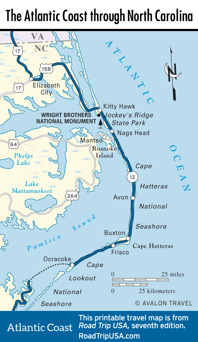
Cape Hatteras National Seashore
The first piece of coastline to be protected as a national park, Cape Hatteras National Seashore stretches for 75 mi (121 km) along the Atlantic Ocean. Starting in the north at Nags Head, and continuing south along slender Bodie, Hatteras, and Ocracoke Islands, the area preserved within Cape Hatteras National Seashore is the largest undeveloped section of coastline on the East Coast, providing an increasingly rare glimpse of nature amid ever-encroaching development. The few old fishing villages that stood here when the seashore was set aside in the 1930s are unfortunately exempt from the antidevelopment prohibitions of the national seashore; these have grown ugly and unwieldy. Nevertheless, the many miles in between remain almost entirely untouched.
For many visitors, the highlight of the national seashore is the historic Cape Hatteras Lighthouse, a mile (1.6 km) south of Hwy-12 at the south end of Hatteras Island. Others come here to enjoy the warm waters and strong, steady winds—two areas of Pamlico Sound on the inland side of Cape Hatteras have been set aside for windsurfers, dozens of whom flock here on summer days to what’s considered one of the finest sailboarding and kite-surfing spots in the United States. And, of course, there are miles of open beaches, perfect for aimless strolling.
At the north end of Cape Hatteras, 8 mi (12.8 km) south of Nags Head, there’s a national seashore visitors center (252/473-2111, daily) and a nature trail winding along Pamlico Sound at the foot of Bodie Island Lighthouse, the first of three historic towers along the Hatteras coast. On the ocean side of Hwy-12, Coquina Beach has a broad strand, lifeguards and outdoor showers in summer, and the remains of a wooden schooner that was wrecked here in the 1920s.
Continuing south, across the Oregon Inlet (where there’s a first-come, first-served campground), Hwy-12 runs through the 5,800-ac (2,347-ha) Pea Island National Wildlife Refuge, which was established in 1937 to protect the nesting grounds of loggerhead sea turtles, as well as the coastal wetlands essential to the survival of the greater snow goose and other migratory waterfowl. South of the refuge, a few short barrages of vacation condos and roadside sprawl—water sport rental shops, casual eateries, souvenir shops, and a KOA campground—line the highway between Rodanthe and Salvo, before the road reaches the heart of the park, where high sand dunes rise along 15 mi (24 km) of undeveloped oceanfront.
Related Travel Guides
North Carolina Travel Map