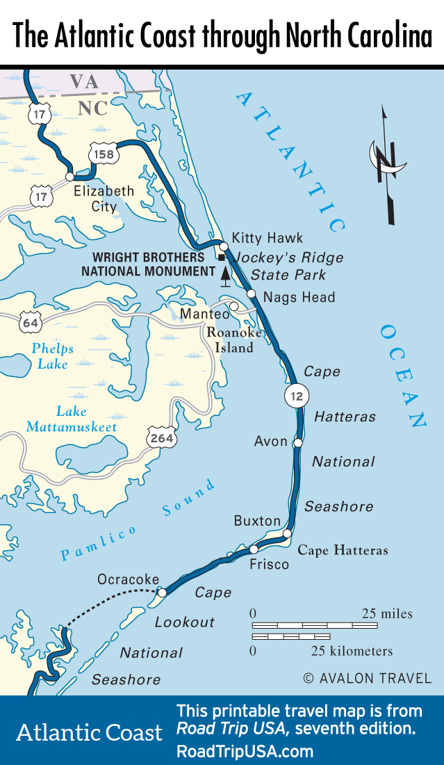
Avon and Buxton: Cape Hatteras Lighthouse
At the rough midpoint of Hatteras Island, the vacation town of Avon stretches for a couple of miles along Hwy-12 before the road hits the Canadian Hole windsurfing area, 2 mi (3.4 km) south of town. After another few miles of natural dunes, the road bends sharply to the west; continuing south here brings you to the main Hatteras Island Visitor Center and Museum of the Sea (252/473-2111, daily) and the famous Cape Hatteras Lighthouse (Apr-Oct., $8). At 210 ft (64 km), the black-and-white-striped lighthouse is the tallest brick lighthouse in the United States, visible from as far as 25 mi (40 km). However, because the ocean here has been slowly eroding the beach (when the lighthouse was built in 1870, it was a quarter-mile (0.4 km) from the waves; by 1995 the coast was a mere 120 ft (36 m) away from its base), in 1999 the National Park Service succeeded in lifting the 4,830-ton lighthouse onto rails and shifting it a half-mile (0.8 km) inland. If you feel fit, climb the 257 stairs to the top of the lighthouse for a grand view—one that gives the clearest sense of just how narrow and transitive the Outer Banks are.
Farther along, at the end of this road, there’s a campground open spring to fall.
From the Cape Hatteras Lighthouse, Hwy-12 bends west and south through Buxton and Frisco. The village of Frisco, 5 mi (8 km) north of the Hatteras ferry terminal, holds the small but surprisingly good Native American Museum (252/995-4440, Tues.-Sun. summer, Sat.-Sun. winter, $5), which boasts an extensive collection of artifacts from several indigenous nations, including those from the Cape Hatteras area, as well as Hopi and Navajo crafts.
In Buxton and Frisco you will find a gauntlet of motels, gas stations, and fast-food restaurants at the commercial center of Cape Hatteras. Buxton’s motels, like the Lighthouse View (800/225-7651), which is right on the beach and also has a good-size swimming pool, are reasonably priced ($69 and up) and clean. Ocean beaches here at the tip of the cape are among the most spectacular anywhere. Swimmers should note that because they are south-facing, they tend to pick up some of the most extreme surf—especially when hurricanes hit—which is why Buxton and Frisco are the local surfing capitals.
More restaurants and motels await in Hatteras, at the southern end of the island. From here, state-run ferries (5am-midnight, free) shuttle at least once every hour across to Ocracoke Island, another mostly unspoiled barrier island where you’ll find great beaches and the pretty village of Ocracoke, at the island’s southern tip.
Related Travel Map
Related Travel Guides